|
search place name
|
||
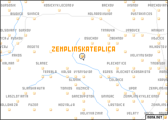
Zemplínska Teplica (Slovakia)Zemplínska Teplica is a town in Slovakia. An overview map of the region around Zemplínska Teplica is displayed below.
regional and 3d topo map of Zemplínska Teplica, Slovakia ::
Zemplínska Teplica airports ::
The nearest airport is KSC - Kosice, located 24.0 km west of Zemplínska Teplica.
Other airports nearby include TAT - Poprad Tatry (108.1 km north west), DEB - Debrecen (129.2 km south), SUJ - Satu Mare (143.9 km south east), RZE - Rzeszow Jasionka (165.7 km north), Nearby towns ::
Vyšný Dvor (3.7km south) //
Osuchov (3.9km north) //
Jozefova Pusta (3.9km south) //
Slanské Nové Mesto (3.1km south west) //
Čaloka (4.4km south east) //
Kalša (4.4km south west) //
Slivník (5.7km south) //
Veľké Ozorovce (4.1km north east) //
Egreš (5.2km south east) //
Malé Ozorovce (5.2km north east) //
Kuzmice (7.4km south) //
Plechotice (5.2km east) //
Slančík (5.2km west) //
Trnavka (6.7km north east) //
Zbehňov (6.1km north east) //
Terebľa (6.1km south west) //
Torkos (7.8km south) //
Čeľovce (7.4km south east) //
[all distances 'as the bird flies' and approximate]  Places with similar names to Zemplínska Teplica, Slovakia :: Disclaimer :: Information on this page comes without warranty of any kind |
||
|
Where is Zemplínska Teplica? Elevation and coordinates ::
Latitude (lat): 48°39'0"N Longitude (lon): 21°34'0"E
Elevation (approx.): 231m (map arrows pan, magnifying glasses zoom) |
||
|
Visiting Zemplínska Teplica? Hotel/Accommodation ::
Book a hotel in Zemplínska Teplica Travel Guide ::
Buy a travel guide for Slovakia rental cars ::
car rental offers GPS waypoint ::
download a GPX waypoint (PoI) of Zemplínska Teplica for your GPS receiver
|
||