|
search place name
|
||
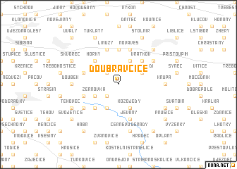
Doubravčice (Czech Republic)Doubravčice is a town in Czech Republic. An overview map of the region around Doubravčice is displayed below.
regional and 3d topo map of Doubravčice, Czech Republic ::
Doubravčice airports ::
The nearest airport is PRG - Prague Ruzyne, located 39.8 km west of Doubravčice.
Other airports nearby include PED - Pardubice (67.3 km east), BBJ - Bautzen (132.4 km north), KLV - Karlovy Vary (136.4 km west), DRS - Dresden (144.1 km north west), Nearby towns ::
Masojedy (2.2km north west) //
Štíhlice (2.2km south west) //
Přehvozdí (3.0km north east) //
Mrzky (3.9km north) //
Žernovka (3.0km south west) //
Vyžlovka (3.9km south) //
Kozojedy (3.9km south) //
Vrátkov (4.4km north east) //
Skřivany (4.4km north west) //
Přišimasy (4.4km north west) //
Horky (4.4km north west) //
Louňovice (4.4km south west) //
Rostoklaty (5.6km north) //
Hradešín (4.0km north west) //
Nová Ves (5.7km north) //
Tismice (5.7km north) //
Límuzy (5.7km north) //
Mukařov (4.0km south west) //
Jevany (5.7km south) //
Tuchoraz (5.1km north east) //
Buda (5.1km south west) //
Srbín (5.1km south west) //
Krupá (4.8km east) //
Babičky (4.8km west) //
Doubek (4.8km west) //
Černé Voděrady (7.5km south) //
Český Brod (6.6km north east) //
Štolmíř (7.8km north) //
Tlustovousy (7.8km north) //
[all distances 'as the bird flies' and approximate]  Places with similar names to Doubravčice, Czech Republic ::
// Dubravčići (CS)
Disclaimer :: Information on this page comes without warranty of any kind |
||
|
Where is Doubravčice? Elevation and coordinates ::
Latitude (lat): 50°1'0"N Longitude (lon): 14°48'0"E
Elevation (approx.): 339m (map arrows pan, magnifying glasses zoom) |
||
|
Visiting Doubravčice? Hotel/Accommodation ::
Book a hotel in Doubravčice Travel Guide ::
rental cars ::
car rental offers GPS waypoint ::
download a GPX waypoint (PoI) of Doubravčice for your GPS receiver
|
||