|
search place name
|
||
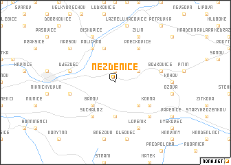
Nezdenice (Czech Republic)Nezdenice is a town in Czech Republic. An overview map of the region around Nezdenice is displayed below.
regional and 3d topo map of Nezdenice, Czech Republic ::
Nezdenice airports ::
The nearest airport is PZY - Piestany, located 43.9 km south of Nezdenice.
Other airports nearby include PRV - Prerov (52.0 km north west), BRQ - Turany (78.5 km west), OSR - Ostrava Mosnov (80.0 km north), BTS - Bratislava M R Stefanik (102.1 km south west), Nearby towns ::
Šumice (1.9km north) //
Kyselka (3.1km north east) //
Záhorovice (3.1km north east) //
Bánov (4.4km south west) //
Bystřice pod Lopeníkem (4.4km south east) //
Ordějov (5.6km south) //
Rudice (5.7km north) //
Polichno (6.1km north west) //
Přečkovice (6.1km north east) //
Suchá Loz (6.1km south west) //
Komňa (5.2km south east) //
Těšov (5.2km west) //
Bojkovice (5.2km east) //
Újezdec (5.2km west) //
Králov (5.2km west) //
Nový Dvŭr (6.6km south east) //
Žilín (7.8km north) //
Kladná (7.8km north) //
Biskupice (7.8km north) //
Lopeník (7.8km south) //
Maršov (7.4km north west) //
[all distances 'as the bird flies' and approximate] 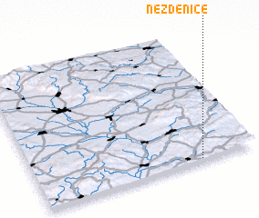 Places with similar names to Nezdenice, Czech Republic ::
// Nestanice (CZ)
Disclaimer :: Information on this page comes without warranty of any kind |
||
|
Where is Nezdenice? Elevation and coordinates ::
Latitude (lat): 49°1'0"N Longitude (lon): 17°45'0"E
Elevation (approx.): 255m (map arrows pan, magnifying glasses zoom) |
||
|
Visiting Nezdenice? Hotel/Accommodation ::
Book a hotel in Nezdenice Travel Guide ::
rental cars ::
car rental offers GPS waypoint ::
download a GPX waypoint (PoI) of Nezdenice for your GPS receiver
|
||