|
search place name
|
||
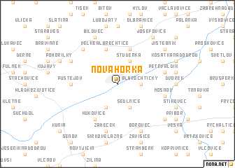
Nová Horka (Czech Republic)Nová Horka is a town in Czech Republic. An overview map of the region around Nová Horka is displayed below.
regional and 3d topo map of Nová Horka, Czech Republic ::
Nová Horka airports ::
The nearest airport is OSR - Ostrava Mosnov, located 3.2 km east of Nová Horka.
Other airports nearby include PRV - Prerov (56.8 km south west), KTW - Katowice Pyrzowice (112.6 km north east), BRQ - Turany (116.8 km south west), PZY - Piestany (120.8 km south), Nearby towns ::
Nádraží (1.9km north) //
Albrechtičky (2.4km east) //
Studénka (3.9km north) //
Sedlnice (3.9km south) //
Bartošovice (3.9km south) //
Butovice (3.0km north west) //
Bravantice (5.7km north) //
Velké Albrechtice (5.7km north) //
Hukovice (6.1km south west) //
Pustějov (4.8km west) //
Harty (5.1km east) //
Petřvaldík (5.1km east) //
Mošnov (5.1km east) //
Zámeček (7.5km south) //
Labuť (6.6km north west) //
Bílov (6.1km north west) //
Borovec (7.8km south) //
Bílovec (7.8km north) //
Jistebník (7.3km north east) //
Prchalov (7.3km south east) //
Josefovice (8.2km north east) //
[all distances 'as the bird flies' and approximate]  Places with similar names to Nová Horka, Czech Republic ::
// Nová Hŭrka (CZ)
Disclaimer :: Information on this page comes without warranty of any kind |
||
|
Where is Nová Horka? Elevation and coordinates ::
Latitude (lat): 49°42'0"N Longitude (lon): 18°4'0"E
Elevation (approx.): 230m (map arrows pan, magnifying glasses zoom) |
||
|
Visiting Nová Horka? Hotel/Accommodation ::
Book a hotel in Nová Horka Travel Guide ::
rental cars ::
car rental offers GPS waypoint ::
download a GPX waypoint (PoI) of Nová Horka for your GPS receiver
|
||