|
search place name
|
||
Oprštěnovice (Czech Republic)Oprštěnovice is a town in Czech Republic. An overview map of the region around Oprštěnovice is displayed below.
regional and 3d topo map of Oprštěnovice, Czech Republic ::

Oprštěnovice airports ::
The nearest airport is OSR - Ostrava Mosnov, located 32.4 km north west of Oprštěnovice.
Other airports nearby include PRV - Prerov (68.6 km west), PZY - Piestany (99.3 km south west), SLD - Sliac (107.0 km south east), KRK - Krakow Balice (124.7 km north east), Nearby towns ::
Pajurcanky (1.9km north) //
Mohyla (2.2km north west) //
V Ondrových (2.2km south west) //
Bečvice (3.7km south) //
Lučovec (3.0km south east) //
Na Mirčici (3.0km south west) //
Msadla (3.9km south) //
Hlavatá (4.4km south east) //
Břestový (5.2km north east) //
Kyčera (5.2km south east) //
V Buckovém (5.2km south west) //
Němčanka (4.8km east) //
Horní Bečva (5.2km west) //
Velký (6.1km north east) //
Salajka (6.1km south east) //
Bumbalka (7.4km south east) //
Na Bařině (8.2km south east) //
[all distances 'as the bird flies' and approximate] 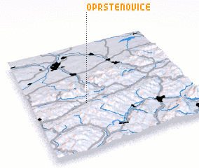 Places with similar names to Oprštěnovice, Czech Republic :: Disclaimer :: Information on this page comes without warranty of any kind |
||
|
Where is Oprštěnovice? Elevation and coordinates ::
Latitude (lat): 49°27'0"N Longitude (lon): 18°21'0"E
Elevation (approx.): 792m (map arrows pan, magnifying glasses zoom) |
||
|
Visiting Oprštěnovice? Hotel/Accommodation ::
Book a hotel in Oprštěnovice Travel Guide ::
rental cars ::
car rental offers GPS waypoint ::
download a GPX waypoint (PoI) of Oprštěnovice for your GPS receiver
|
||