|
search place name
|
||
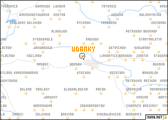
Udánky (Czech Republic)Udánky is a town in Czech Republic. An overview map of the region around Udánky is displayed below.
regional and 3d topo map of Udánky, Czech Republic ::
Udánky airports ::
The nearest airport is PRV - Prerov, located 66.4 km south east of Udánky.
Other airports nearby include BRQ - Turany (68.5 km south), PED - Pardubice (71.0 km north west), OSR - Ostrava Mosnov (105.6 km east), WRO - Wroclaw Strachowice (149.6 km north), Nearby towns ::
Sušice (2.2km north east) //
Boršov (2.2km south west) //
Moravská Třebová (2.2km south east) //
Kunčina (3.7km north) //
Útěchov (3.7km south) //
Radišov (3.9km north) //
Staré Město (4.4km north east) //
Linhartice (3.6km east) //
Bílá Studně (4.0km north east) //
Nová Ves (5.2km north west) //
Malíkov (5.2km south east) //
Rychnov (7.4km north) //
Dětřichov (5.1km east) //
Dlouhá Loučka (7.5km south) //
Mladějov (6.6km north west) //
Ludvíkov (7.8km south) //
Pacov (7.8km south) //
Rozstání (6.1km south east) //
Třebařov (8.2km north east) //
[all distances 'as the bird flies' and approximate] 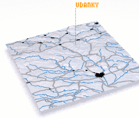 Places with similar names to Udánky, Czech Republic ::
Disclaimer :: Information on this page comes without warranty of any kind |
||
|
Where is Udánky? Elevation and coordinates ::
Latitude (lat): 49°46'0"N Longitude (lon): 16°39'0"E
Elevation (approx.): 357m (map arrows pan, magnifying glasses zoom) |
||
|
Visiting Udánky? Hotel/Accommodation ::
Book a hotel in Udánky Travel Guide ::
rental cars ::
car rental offers GPS waypoint ::
download a GPX waypoint (PoI) of Udánky for your GPS receiver
|
||