|
search place name
|
||
Úhonice (Czech Republic)Úhonice is a town in Czech Republic. An overview map of the region around Úhonice is displayed below.
regional and 3d topo map of Úhonice, Czech Republic ::

Úhonice airports ::
The nearest airport is PRG - Prague Ruzyne, located 7.9 km north east of Úhonice.
Other airports nearby include KLV - Karlovy Vary (92.3 km west), PED - Pardubice (111.5 km east), DRS - Dresden (124.0 km north), BBJ - Bautzen (129.4 km north), Nearby towns ::
Ptice (1.2km west) //
Dolní Ptice (1.2km west) //
Hájek (1.9km north) //
Červený Újezd (2.2km north west) //
Drahelčice (2.2km south east) //
Svárov (3.0km north west) //
Hořelice (3.0km south east) //
Rudná (3.0km south east) //
Nenačovice (4.4km south west) //
Unhošť (4.4km north west) //
Jeneč (4.4km north east) //
Pavlov (5.7km north) //
Vysoký Újezd (5.7km south) //
Dušníky (4.0km south east) //
Chýně (4.0km north east) //
Chrustenice (6.0km south west) //
Nučice (5.1km south east) //
Litovice (5.1km north east) //
Letník (6.0km south east) //
Mezouň (6.0km south east) //
Horní Podkozí (4.8km west) //
Loděnice (7.5km south) //
Lužce (7.5km south) //
Břve (5.1km east) //
Hostouň (7.5km north) //
Malé Přítočno (6.6km north west) //
Malé Přílepy (6.0km south west) //
Tachlovice (6.0km south east) //
Jeneček (6.0km north east) //
[all distances 'as the bird flies' and approximate] 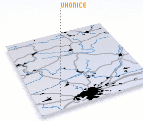 Places with similar names to Úhonice, Czech Republic :: Disclaimer :: Information on this page comes without warranty of any kind |
||
|
Where is Úhonice? Elevation and coordinates ::
Latitude (lat): 50°3'0"N Longitude (lon): 14°11'0"E
Elevation (approx.): 392m (map arrows pan, magnifying glasses zoom) |
||
|
Visiting Úhonice? Hotel/Accommodation ::
Book a hotel in Úhonice Travel Guide ::
rental cars ::
car rental offers GPS waypoint ::
download a GPX waypoint (PoI) of Úhonice for your GPS receiver
|
||