|
search place name
|
||
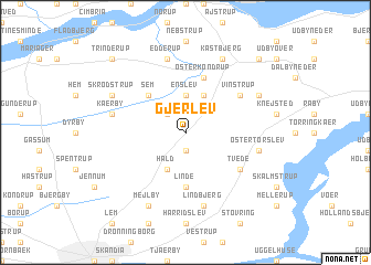
Gjerlev (Århus, Denmark)Gjerlev is a town in the Århus region of Denmark. An overview map of the region around Gjerlev is displayed below.
regional and 3d topo map of Gjerlev, Denmark ::
Gjerlev airports ::
The nearest airport is AAR - Aarhus, located 43.5 km south east of Gjerlev.
Other airports nearby include AAL - Aalborg (59.3 km north), KRP - Karup (69.9 km south west), TED - Thisted (102.6 km north west), BLL - Billund (111.9 km south west), Nearby towns ::
Stovby (1.9km south) //
Blenstrup (2.1km north west) //
Enslev (3.7km north) //
Hald (3.8km south) //
Stangerum (3.8km north) //
Sem (4.2km north west) //
Linde (5.6km south) //
Øster Kondrup (5.7km north) //
Tvede (4.8km south east) //
Vinstrup (4.8km north east) //
Lindbjerg (7.5km south) //
Kærby (4.5km north west) //
Edderup (7.5km north) //
Øster Tørslev (4.5km south east) //
Ilshøj (4.5km south east) //
Mejlby (7.7km south) //
Skrødstrup (5.5km north west) //
Kastbjerg (7.7km north) //
Dalbyover (5.5km north east) //
Trinderup (8.5km north west) //
Havndal (8.5km north east) //
[all distances 'as the bird flies' and approximate] 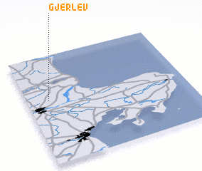 Places with similar names to Gjerlev, Denmark :: Disclaimer :: Information on this page comes without warranty of any kind |
||
|
Where is Gjerlev? Elevation and coordinates ::
Latitude (lat): 56°35'0"N Longitude (lon): 10°8'0"E
Elevation (approx.): 30m (map arrows pan, magnifying glasses zoom) |
||
|
Visiting Gjerlev? Hotel/Accommodation ::
Book a hotel in Gjerlev Travel Guide ::
Buy a travel guide for Denmark rental cars ::
car rental offers GPS waypoint ::
download a GPX waypoint (PoI) of Gjerlev for your GPS receiver
|
||