|
search place name
|
||
Krakken (Bornholm, Denmark)Krakken is a town in the Bornholm region of Denmark. An overview map of the region around Krakken is displayed below.
regional and 3d topo map of Krakken, Denmark ::

Krakken airports ::
The nearest airport is RNN - Bornholm Ronne, located 20.8 km south of Krakken.
Other airports nearby include KID - Kristianstad (86.2 km north west), MMX - Malmoe Sturup (93.7 km west), RNB - Ronneby (117.4 km north), JLD - Landskrona (142.4 km north west), Nearby towns ::
Vang (1.1km west) //
Sandvig (3.9km north) //
Fuglesangen (3.9km south) //
Rutsker (3.9km south) //
Kåsby (4.3km south west) //
Sandkås (3.2km east) //
Kirkeby (5.7km south) //
Olsker (3.7km south east) //
Allinge (3.7km north east) //
Teglkås (4.9km south west) //
Helligpeder (4.9km south west) //
Vysteby (5.9km south) //
Krummeled (7.4km south) //
Duebjerggård (7.4km south) //
Hasle (8.1km south west) //
[all distances 'as the bird flies' and approximate] 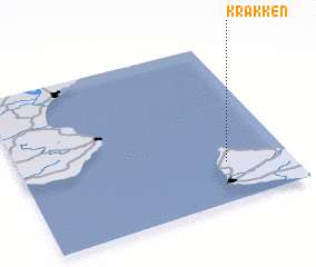 Places with similar names to Krakken, Denmark ::
Disclaimer :: Information on this page comes without warranty of any kind |
||
|
Where is Krakken? Elevation and coordinates ::
Latitude (lat): 55°15'0"N Longitude (lon): 14°46'0"E
Elevation (approx.): 113m (map arrows pan, magnifying glasses zoom) |
||
|
Visiting Krakken? Hotel/Accommodation ::
Book a hotel in Krakken Travel Guide ::
Buy a travel guide for Denmark rental cars ::
car rental offers GPS waypoint ::
download a GPX waypoint (PoI) of Krakken for your GPS receiver
|
||