|
search place name
|
||
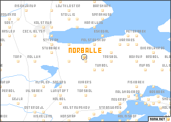
Nørballe (Sønderjylland, Denmark)Nørballe is a town in the Sønderjylland region of Denmark. An overview map of the region around Nørballe is displayed below.
regional and 3d topo map of Nørballe, Denmark ::
Nørballe airports ::
The nearest airport is SGD - Soenderborg Sonderborg, located 18.8 km east of Nørballe.
Other airports nearby include SKS - Skrydstrup (30.9 km north west), GWT - Westerland Sylt (74.7 km west), ODE - Odense (76.2 km north east), KEL - Kiel Holtenau (79.1 km south east), Nearby towns ::
Slyngsten (0.0km north) //
Felsted (2.1km south east) //
Sønder Hostrup (2.1km west) //
Tumbøl (2.8km south east) //
Bøgholm (2.8km north east) //
Felstedskov (3.9km north) //
Eliselund (4.3km north west) //
Kværs (5.6km south) //
Tråsbøl (3.2km east) //
Svejrup (3.2km east) //
Gammel Skovbøl (3.7km north east) //
Eskedal (6.0km north) //
Tørsbøl (7.4km south) //
Avbæk (7.5km north) //
Marielund (7.5km north) //
Dyrhave (7.5km north) //
Stubbæk (4.6km north west) //
Søgård (6.4km south west) //
Styrtom (5.6km north west) //
Hostrupskov (5.6km north west) //
Dyrbæk (5.6km north east) //
Lundtoft (8.1km south west) //
Åbenrå (7.0km north west) //
Jørgensgård (8.5km north west) //
[all distances 'as the bird flies' and approximate] 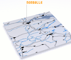 Places with similar names to Nørballe, Denmark ::
Disclaimer :: Information on this page comes without warranty of any kind |
||
|
Where is Nørballe? Elevation and coordinates ::
Latitude (lat): 54°59'0"N Longitude (lon): 9°30'0"E
Elevation (approx.): 48m (map arrows pan, magnifying glasses zoom) |
||
|
Visiting Nørballe? Hotel/Accommodation ::
Book a hotel in Nørballe Travel Guide ::
Buy a travel guide for Denmark rental cars ::
car rental offers GPS waypoint ::
download a GPX waypoint (PoI) of Nørballe for your GPS receiver
|
||