|
search place name
|
||
Nybølle Hede (Storstrøm, Denmark)Nybølle Hede is a town in the Storstrøm region of Denmark. An overview map of the region around Nybølle Hede is displayed below.
regional and 3d topo map of Nybølle Hede, Denmark ::

Nybølle Hede airports ::
The nearest airport is ODE - Odense, located 82.1 km north west of Nybølle Hede.
Other airports nearby include RKE - Copenhagen Roskilde (90.9 km north east), SGD - Soenderborg Sonderborg (92.4 km west), KEL - Kiel Holtenau (94.7 km south west), CPH - Copenhagen Kastrup (117.0 km north east), Nearby towns ::
Nybølle (1.9km south) //
Kastager (2.1km south west) //
Nørre Tvede (2.1km south east) //
Ravnsholt (2.8km south east) //
Utterslev (4.3km south west) //
Svinsbjerg (4.3km south east) //
Utterslevmader (3.2km west) //
Urne (3.2km east) //
Horslunde (5.6km south) //
Nøbbet (3.7km south east) //
Ørsløkke (5.7km south) //
Bøgeskov (7.4km south) //
Øster Nordlunde (7.4km south) //
Vester Nordlunde (7.4km south) //
Tjørneby (4.6km south west) //
Sandbjerg (6.4km south west) //
Vindeby (5.6km south west) //
Hjelmholt (5.6km south east) //
Skredtorpe (7.0km south west) //
Lille Løjtofte (8.1km south west) //
Magletving (8.6km south east) //
[all distances 'as the bird flies' and approximate] 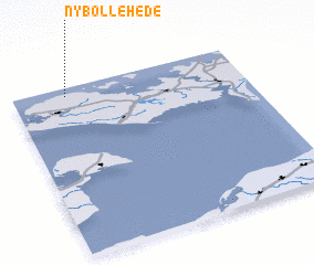 Places with similar names to Nybølle Hede, Denmark :: Disclaimer :: Information on this page comes without warranty of any kind |
||
|
Where is Nybølle Hede? Elevation and coordinates ::
Latitude (lat): 54°57'0"N Longitude (lon): 11°14'0"E
Elevation (approx.): 3m (map arrows pan, magnifying glasses zoom) |
||
|
Visiting Nybølle Hede? Hotel/Accommodation ::
Book a hotel in Nybølle Hede Travel Guide ::
Buy a travel guide for Denmark rental cars ::
car rental offers GPS waypoint ::
download a GPX waypoint (PoI) of Nybølle Hede for your GPS receiver
|
||