|
search place name
|
||
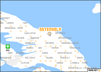
Østerholm (Sønderjylland, Denmark)Østerholm is a town in the Sønderjylland region of Denmark. An overview map of the region around Østerholm is displayed below.
regional and 3d topo map of Østerholm, Denmark ::
Østerholm airports ::
The nearest airport is SGD - Soenderborg Sonderborg, located 9.9 km south west of Østerholm.
Other airports nearby include SKS - Skrydstrup (49.6 km north west), ODE - Odense (58.8 km north east), KEL - Kiel Holtenau (70.4 km south), BLL - Billund (96.2 km north west), Nearby towns ::
Hundslev (2.1km south west) //
Elstrup (2.1km west) //
Notmark (3.7km south) //
Frederikshof (2.1km east) //
Helleved (2.1km east) //
Ketting (3.9km south) //
Almsted (3.9km south) //
Katryde (2.8km south east) //
Asserballe (4.3km south east) //
Tovrup (5.7km south) //
Guderup (3.7km south west) //
Notmarkskov (3.7km south east) //
Fynshav (3.7km south east) //
Bro (6.0km south) //
Egen (4.9km south west) //
Sjellerup (4.3km west) //
Dyndved (4.6km south west) //
Kirke-Hørup (7.5km south) //
Mjang (7.5km south) //
Augustenborg (6.4km south west) //
Kettingskov (6.4km south east) //
Sebbelev (5.6km south west) //
Lambjerg (7.7km south) //
Asserballeskov (5.6km south east) //
Jestrup (7.7km south) //
Osbæk (7.0km south west) //
Over Tandslet (8.1km south east) //
Ertebjerg (8.1km south east) //
[all distances 'as the bird flies' and approximate] 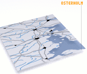 Places with similar names to Østerholm, Denmark ::
// Osterholm (DE)
Disclaimer :: Information on this page comes without warranty of any kind |
||
|
Where is Østerholm? Elevation and coordinates ::
Latitude (lat): 55°0'0"N Longitude (lon): 9°56'0"E
Elevation (approx.): 37m (map arrows pan, magnifying glasses zoom) |
||
|
Visiting Østerholm? Hotel/Accommodation ::
Book a hotel in Østerholm Travel Guide ::
Buy a travel guide for Denmark rental cars ::
car rental offers GPS waypoint ::
download a GPX waypoint (PoI) of Østerholm for your GPS receiver
|
||