|
search place name
|
||
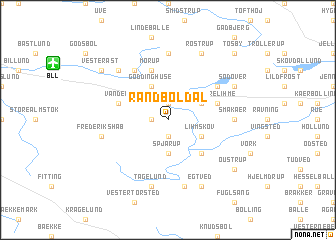
Randbøldal (Vejle, Denmark)Randbøldal is a town in the Vejle region of Denmark. An overview map of the region around Randbøldal is displayed below.
regional and 3d topo map of Randbøldal, Denmark ::
Randbøldal airports ::
The nearest airport is BLL - Billund, located 9.6 km north west of Randbøldal.
Other airports nearby include EBJ - Esbjerg (48.2 km west), SKS - Skrydstrup (51.0 km south), STA - Stauning (66.6 km north west), KRP - Karup (68.9 km north), Nearby towns ::
Bindeballe (1.9km south) //
Daldover (1.0km west) //
Lille Lihme (1.9km north) //
Randbøl (1.9km north) //
Spjarup (3.7km south) //
Lihmskov (2.8km south east) //
Ny Nørup (2.8km north east) //
Gødding Huse (3.9km north) //
Refsgårde (4.3km south east) //
Mørup (5.7km north) //
Vandel (3.6km north west) //
Store Lihme (3.6km north east) //
Øster Åst (5.9km north) //
Nørup (4.9km north east) //
Småkær (4.2km east) //
Førstballe (7.4km north) //
Bøgvad (7.5km south) //
Tågelund (7.5km south) //
Frederikshåb (4.6km south west) //
Åst (6.4km north west) //
Egtved (7.7km south) //
Sødover (5.6km north east) //
Rostrup (7.7km north) //
Oustrup (7.0km south east) //
Vester Åst (7.0km north west) //
Tøsby (8.5km north east) //
[all distances 'as the bird flies' and approximate] 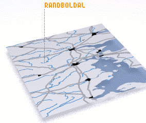 Places with similar names to Randbøldal, Denmark :: Disclaimer :: Information on this page comes without warranty of any kind |
||
|
Where is Randbøldal? Elevation and coordinates ::
Latitude (lat): 55°41'0"N Longitude (lon): 9°16'0"E
Elevation (approx.): 48m (map arrows pan, magnifying glasses zoom) |
||
|
Visiting Randbøldal? Hotel/Accommodation ::
Book a hotel in Randbøldal Travel Guide ::
Buy a travel guide for Denmark rental cars ::
car rental offers GPS waypoint ::
download a GPX waypoint (PoI) of Randbøldal for your GPS receiver
|
||