|
search place name
|
||
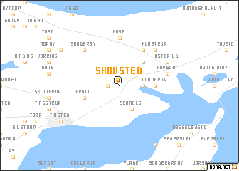
Skovsted (Viborg, Denmark)Skovsted is a town in the Viborg region of Denmark. An overview map of the region around Skovsted is displayed below.
regional and 3d topo map of Skovsted, Denmark ::
Skovsted airports ::
The nearest airport is TED - Thisted, located 9.0 km north west of Skovsted.
Other airports nearby include AAL - Aalborg (65.5 km east), KRP - Karup (81.0 km south), STA - Stauning (115.5 km south), AAR - Aarhus (136.9 km south east), Nearby towns ::
Kjelstrup (1.0km west) //
Kåstrup (2.1km north west) //
Hov (2.0km east) //
Hillerslev (2.7km north west) //
Hundal (3.8km south) //
Sennels (3.8km south) //
Malle (3.8km south) //
Kløv (2.7km north east) //
Hunstrup (4.2km north east) //
Lønnerup (3.0km east) //
Brund (3.6km south west) //
Hjardemål (5.9km north) //
Kåse (7.4km north) //
Hovsør (4.4km north east) //
Klastrup (6.3km north east) //
Ballerum (6.3km north west) //
Sønderby (6.3km north west) //
Østerild (5.5km north east) //
[all distances 'as the bird flies' and approximate] 
Disclaimer :: Information on this page comes without warranty of any kind |
||
|
Where is Skovsted? Elevation and coordinates ::
Latitude (lat): 57°0'0"N Longitude (lon): 8°47'0"E
Elevation (approx.): 15m (map arrows pan, magnifying glasses zoom) |
||
|
Visiting Skovsted? Hotel/Accommodation ::
Book a hotel in Skovsted Travel Guide ::
Buy a travel guide for Denmark rental cars ::
car rental offers GPS waypoint ::
download a GPX waypoint (PoI) of Skovsted for your GPS receiver
|
||