|
search place name
|
||
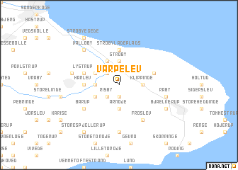
Varpelev (Roskilde, Denmark)Varpelev is a town in the Roskilde region of Denmark. An overview map of the region around Varpelev is displayed below.
regional and 3d topo map of Varpelev, Denmark ::
Varpelev airports ::
The nearest airport is RKE - Copenhagen Roskilde, located 28.3 km north of Varpelev.
Other airports nearby include CPH - Copenhagen Kastrup (37.4 km north east), MMX - Malmoe Sturup (70.7 km east), JLD - Landskrona (75.3 km north east), ODE - Odense (125.5 km west), Nearby towns ::
Tåstrup (1.9km south) //
Risby (2.1km south west) //
Lille Tårnby (2.1km north west) //
Strøby (3.7km north) //
Klippinge (2.1km east) //
Ammerup (2.1km west) //
Arnøje (3.7km south) //
Store Tårnby (3.9km north) //
Stolpehuse (2.8km north west) //
Hellested (2.8km south west) //
Strøby Ladeplads (5.6km north) //
Hårlev (3.2km west) //
Magleby (3.7km north east) //
Lystrup (3.7km north west) //
Barup (4.9km south west) //
Frøslev (5.9km south) //
Lyderslev (7.4km south) //
Råby (4.6km south east) //
Himlingøje (4.6km north west) //
Valløby (6.4km north west) //
Bjælkerup (5.6km south east) //
Strøby Egede (8.1km north west) //
Store Spjellerup (8.1km south west) //
Smerup (8.1km south west) //
[all distances 'as the bird flies' and approximate] 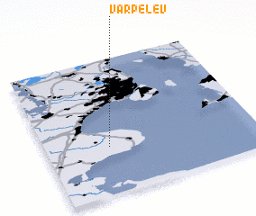 Places with similar names to Varpelev, Denmark :: Disclaimer :: Information on this page comes without warranty of any kind |
||
|
Where is Varpelev? Elevation and coordinates ::
Latitude (lat): 55°21'0"N Longitude (lon): 12°18'0"E
Elevation (approx.): 16m (map arrows pan, magnifying glasses zoom) |
||
|
Visiting Varpelev? Hotel/Accommodation ::
Book a hotel in Varpelev Travel Guide ::
Buy a travel guide for Denmark rental cars ::
car rental offers GPS waypoint ::
download a GPX waypoint (PoI) of Varpelev for your GPS receiver
|
||