|
search place name
|
||
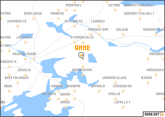
Åmme (Örebro, Sweden)Åmme is a town in the Örebro region of Sweden. An overview map of the region around Åmme is displayed below.
regional and 3d topo map of Åmme, Sweden ::
Åmme airports ::
The nearest airport is ORB - Orebro, located 38.0 km north of Åmme.
Other airports nearby include KSK - Karlskoga (59.1 km north west), LPI - Linkoeping Saab (66.2 km south east), KVB - Skovde (76.3 km south west), NRK - Norrkoeping Kungsangen (79.6 km south east), Nearby towns ::
Alsnäs (0.0km north) //
Åmmeberg (1.9km south) //
Norra Kärra (3.7km south) //
Stimmerkulla (3.7km north) //
Ingelsby (3.8km north) //
Rönne (5.6km north) //
Rönneshytta (5.9km north) //
Rönnestorp (5.9km north) //
Ängarna (7.5km south) //
Skyllberg (7.5km north) //
Uppsala (7.7km south) //
Lerbäck (7.7km north) //
Hammar (8.0km south) //
Johanneslund (6.8km south east) //
[all distances 'as the bird flies' and approximate] 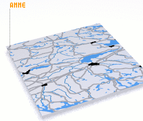 Places with similar names to Åmme, Sweden ::
Disclaimer :: Information on this page comes without warranty of any kind |
||
|
Where is Åmme? Elevation and coordinates ::
Latitude (lat): 58°53'0"N Longitude (lon): 15°0'0"E
Elevation (approx.): 109m (map arrows pan, magnifying glasses zoom) |
||
|
Visiting Åmme? Hotel/Accommodation ::
Book a hotel in Åmme Travel Guide ::
Buy a travel guide for Sweden rental cars ::
car rental offers GPS waypoint ::
download a GPX waypoint (PoI) of Åmme for your GPS receiver
|
||