|
search place name
|
||
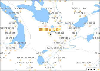
Arnästorp (Värmland, Sweden)Arnästorp is a town in the Värmland region of Sweden. An overview map of the region around Arnästorp is displayed below.
regional and 3d topo map of Arnästorp, Sweden ::
Arnästorp airports ::
The nearest airport is KSK - Karlskoga, located 65.1 km east of Arnästorp.
Other airports nearby include ORB - Orebro (98.8 km east), LDK - Lidkoping (123.6 km south), KVB - Skovde (127.5 km south), THN - Trollhattan Vanersborg (152.5 km south west), Nearby towns ::
Nybacka (0.0km north) //
Orretorp (0.0km west) //
Grossbolstorp (2.1km south east) //
Visterud (1.9km east) //
Dömle (3.8km north) //
Deje (4.2km north east) //
Forshaga (4.2km south east) //
Grossbol (4.2km south east) //
Hedås (5.6km south) //
Sundstad (3.4km south east) //
Tjärn (5.6km north) //
Skivetorp (5.9km south) //
Dejeforsbruk (5.9km north) //
Dyvelsten (7.4km south) //
Hedegården (7.5km north) //
Öjenäs (7.6km south) //
Tjusbol (5.3km north east) //
[all distances 'as the bird flies' and approximate]  Places with similar names to Arnästorp, Sweden ::
// Arnstorp (SE)
Disclaimer :: Information on this page comes without warranty of any kind |
||
|
Where is Arnästorp? Elevation and coordinates ::
Latitude (lat): 59°34'0"N Longitude (lon): 13°26'0"E
Elevation (approx.): 64m (map arrows pan, magnifying glasses zoom) |
||
|
Visiting Arnästorp? Hotel/Accommodation ::
Book a hotel in Arnästorp Travel Guide ::
Buy a travel guide for Sweden rental cars ::
car rental offers GPS waypoint ::
download a GPX waypoint (PoI) of Arnästorp for your GPS receiver
|
||