|
search place name
|
||
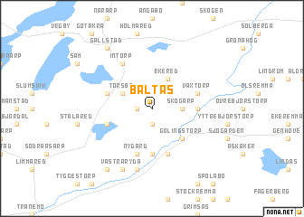
Baltås ((( Älvsborg )), Sweden)Baltås is a town in the (( Älvsborg )) region of Sweden. An overview map of the region around Baltås is displayed below.
regional and 3d topo map of Baltås, Sweden ::
Baltås airports ::
The nearest airport is JKG - Joenkoeping Jonkoping, located 39.1 km north east of Baltås.
Other airports nearby include GOT - Gothenborg Landvetter (72.2 km west), LDK - Lidkoping (98.1 km north), GSE - Gothenborg Save (98.2 km west), KVB - Skovde (99.7 km north), Nearby towns ::
Långared (1.0km west) //
Nittorp (1.9km south) //
Dalstorp (2.1km north east) //
Skogarp (2.0km east) //
Ekered (3.8km north) //
Torsbo (2.7km north west) //
Gölingstorp (4.2km south east) //
Hjärtared (3.0km east) //
Gisslarp (5.6km south) //
Nittorp (5.6km south) //
Nygård (5.6km south) //
Kättebo (3.5km north west) //
Växtorp (3.5km north east) //
Gryttered (3.5km south west) //
Hornhult (5.6km south) //
Intorp (5.9km north) //
Östra Ryda (7.5km south) //
Västra Ryda (7.7km south) //
Andlabo (8.0km south) //
Gällstad (8.0km north) //
[all distances 'as the bird flies' and approximate] 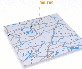 Places with similar names to Baltås, Sweden ::
Disclaimer :: Information on this page comes without warranty of any kind |
||
|
Where is Baltås? Elevation and coordinates ::
Latitude (lat): 57°36'0"N Longitude (lon): 13°29'0"E
Elevation (approx.): 239m (map arrows pan, magnifying glasses zoom) |
||
|
Visiting Baltås? Hotel/Accommodation ::
Book a hotel in Baltås Travel Guide ::
Buy a travel guide for Sweden rental cars ::
car rental offers GPS waypoint ::
download a GPX waypoint (PoI) of Baltås for your GPS receiver
|
||