|
search place name
|
||
Bonserud (Värmland, Sweden)Bonserud is a town in the Värmland region of Sweden. An overview map of the region around Bonserud is displayed below.
regional and 3d topo map of Bonserud, Sweden ::

Bonserud airports ::
The nearest airport is KSK - Karlskoga, located 74.1 km south east of Bonserud.
Other airports nearby include ORB - Orebro (107.8 km south east), LDK - Lidkoping (132.3 km south), KVB - Skovde (137.9 km south), THN - Trollhattan Vanersborg (158.9 km south), Nearby towns ::
Gunnarsby (2.1km south west) //
Tomthult (3.7km south) //
Nilsby (3.8km south) //
Ulvsby (3.8km south) //
Humletorp (3.8km north) //
Prästhamna (2.8km west) //
Hastersby (5.6km south) //
Ängarne (5.3km north east) //
Annita (7.7km south) //
Nedre Bondestad (7.9km south) //
[all distances 'as the bird flies' and approximate] 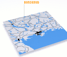 Places with similar names to Bonserud, Sweden ::
// Bansirit (PH)
// Buena Suerte (PH)
// Bansrade (DE)
// Buena Suerte (CU)
// Banī Surayd (EG)
// Bŭnzareto (BG)
// Bān Zardeh (IR)
// Bān Zīārat (IR)
// Boneh Zard (IR)
// Buena Suerte (EC)
Disclaimer :: Information on this page comes without warranty of any kind |
||
|
Where is Bonserud? Elevation and coordinates ::
Latitude (lat): 59°39'0"N Longitude (lon): 13°20'0"E
Elevation (approx.): 129m (map arrows pan, magnifying glasses zoom) |
||
|
Visiting Bonserud? Hotel/Accommodation ::
Book a hotel in Bonserud Travel Guide ::
Buy a travel guide for Sweden rental cars ::
car rental offers GPS waypoint ::
download a GPX waypoint (PoI) of Bonserud for your GPS receiver
|
||