|
search place name
|
||
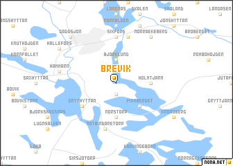
Brevik (Örebro, Sweden)Brevik is a town in the Örebro region of Sweden. An overview map of the region around Brevik is displayed below.
regional and 3d topo map of Brevik, Sweden ::
Brevik airports ::
The nearest airport is KSK - Karlskoga, located 43.4 km south of Brevik.
Other airports nearby include ORB - Orebro (62.3 km south east), BLE - Borlange (92.6 km north east), MXX - Mora (136.5 km north), KVB - Skovde (146.5 km south), Nearby towns ::
Hälgsnäs (1.9km south) //
Kastenhult (1.9km north) //
Björklund (3.7km north) //
Finnberget (4.2km south east) //
Norstorp (5.6km south) //
Holmtjärn (2.8km east) //
Grythyttan (4.6km south west) //
Sikfors (7.4km north) //
Notbindaretorp (7.5km south) //
Nytorp (7.5km north) //
Norra Ekeberg (7.9km north) //
Gäddsjön (8.3km north west) //
[all distances 'as the bird flies' and approximate] 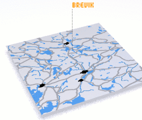 Places with similar names to Brevik, Sweden ::
Disclaimer :: Information on this page comes without warranty of any kind |
||
|
Where is Brevik? Elevation and coordinates ::
Latitude (lat): 59°44'0"N Longitude (lon): 14°35'0"E
Elevation (approx.): 189m (map arrows pan, magnifying glasses zoom) |
||
|
Visiting Brevik? Hotel/Accommodation ::
Book a hotel in Brevik Travel Guide ::
Buy a travel guide for Sweden rental cars ::
car rental offers GPS waypoint ::
download a GPX waypoint (PoI) of Brevik for your GPS receiver
|
||