|
search place name
|
||
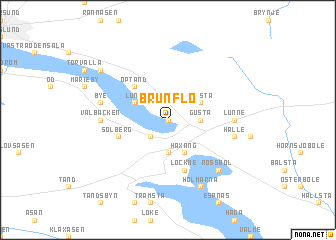
Brunflo (Jämtland, Sweden)Brunflo is a town in the Jämtland region of Sweden. An overview map of the region around Brunflo is displayed below.
regional and 3d topo map of Brunflo, Sweden ::
Brunflo airports ::
The nearest airport is OSD - Ostersund Froson, located 20.1 km north west of Brunflo.
Other airports nearby include EVG - Sveg (117.2 km south), Nearby towns ::
Viken (0.0km north) //
Grytans Läger (2.0km north east) //
Sörviken (2.0km south west) //
Grytan (2.0km north west) //
Gusta (1.7km east) //
Ede (3.7km south) //
Haxäng (3.8km south) //
Vamsta (2.5km north east) //
Lund (2.5km north west) //
Optand (4.1km north west) //
Lockne (5.6km south) //
Solberg (3.1km south west) //
Gärde (3.4km east) //
Lunne (3.4km east) //
Överbyn (3.4km west) //
Vålbacken (3.4km west) //
Hälle (3.8km south east) //
Bye (3.8km north west) //
Rossbol (6.1km south east) //
Holmarna (7.6km south) //
Ope (6.5km north west) //
[all distances 'as the bird flies' and approximate]  Places with similar names to Brunflo, Sweden ::
// Brownville (US)
// Brownville (US)
// Burnville (US)
// Brownville (US)
// Byrneville (US)
// Barneyville (US)
// Byrneville (US)
// Brownville (US)
// Brownville (US)
// Brañavella (ES)
Disclaimer :: Information on this page comes without warranty of any kind |
||
|
Where is Brunflo? Elevation and coordinates ::
Latitude (lat): 63°5'0"N Longitude (lon): 14°49'0"E
(map arrows pan, magnifying glasses zoom) |
||
|
Visiting Brunflo? Hotel/Accommodation ::
Book a hotel in Brunflo Travel Guide ::
Buy a travel guide for Sweden rental cars ::
car rental offers GPS waypoint ::
download a GPX waypoint (PoI) of Brunflo for your GPS receiver
|
||