|
search place name
|
||
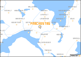
Fräckestad ((( Älvsborg )), Sweden)Fräckestad is a town in the (( Älvsborg )) region of Sweden. An overview map of the region around Fräckestad is displayed below.
regional and 3d topo map of Fräckestad, Sweden ::
Fräckestad airports ::
The nearest airport is KVB - Skovde, located 35.5 km south west of Fräckestad.
Other airports nearby include ORB - Orebro (70.5 km north east), KSK - Karlskoga (74.0 km north), LDK - Lidkoping (75.3 km west), LPI - Linkoeping Saab (80.7 km east), Nearby towns ::
Kullen (1.9km north) //
Ärlagården (2.1km south west) //
Lindåsen (2.1km north west) //
Undenäs (3.8km south) //
Lindberga (3.8km north) //
Björstorp (3.4km south west) //
Närlunda (3.4km south west) //
Lindhult (5.6km north) //
Igelstad (3.4km north east) //
Sätra (3.4km north west) //
Havsmon (3.9km east) //
Mellanskogen (7.5km south) //
Skagen (7.5km north) //
Gersebacken (8.4km north west) //
Bredebolet (8.4km north west) //
[all distances 'as the bird flies' and approximate] 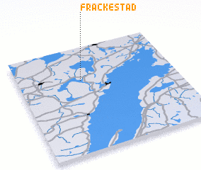 Places with similar names to Fräckestad, Sweden ::
Disclaimer :: Information on this page comes without warranty of any kind |
||
|
Where is Fräckestad? Elevation and coordinates ::
Latitude (lat): 58°41'0"N Longitude (lon): 14°24'0"E
Elevation (approx.): 123m (map arrows pan, magnifying glasses zoom) |
||
|
Visiting Fräckestad? Hotel/Accommodation ::
Book a hotel in Fräckestad Travel Guide ::
Buy a travel guide for Sweden rental cars ::
car rental offers GPS waypoint ::
download a GPX waypoint (PoI) of Fräckestad for your GPS receiver
|
||