|
search place name
|
||
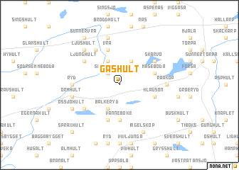
Gashult (Kronoberg, Sweden)Gashult is a town in the Kronoberg region of Sweden. An overview map of the region around Gashult is displayed below.
regional and 3d topo map of Gashult, Sweden ::
Gashult airports ::
The nearest airport is HAD - Halmstad, located 40.7 km west of Gashult.
Other airports nearby include VXO - Vaxjo Kronoberg (81.5 km east), JLD - Landskrona (88.9 km south west), KID - Kristianstad (90.9 km south east), RNB - Ronneby (118.5 km east), Nearby towns ::
Skifteryd (2.1km north west) //
Hästhult (3.8km north) //
Skärseryd (3.8km north) //
Balkeryd (3.8km south) //
Vänneböke (5.6km south) //
Åkerbergshult (5.7km north) //
Skinnersböke (5.7km south) //
Vrå (5.7km north) //
Mäseboda (3.6km north east) //
Klausön (3.6km south east) //
Mäste (5.9km north) //
Ljunghult (4.8km north west) //
Skärvö (4.8km north east) //
Össjöa (4.8km south west) //
Ryd (4.1km west) //
Råaköp (4.1km east) //
Bjärseryd (7.5km north) //
Ormhult (4.5km south west) //
Ljushult (6.3km north west) //
Össjöhult (5.5km south west) //
Ingelsköp (7.7km south) //
Sunnervrå (8.0km north) //
Språxhult (8.5km south west) //
[all distances 'as the bird flies' and approximate] 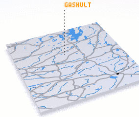 Places with similar names to Gashult, Sweden ::
// Gacia Alto (ES)
// Gucialit (ID)
// Kachal Deh (IR)
// C. Chalate (MZ)
// Cachalot (CA)
// Kʼeshelʼta (GE)
// Cachuelita (BO)
// Gåshult (SE)
// Göshult (SE)
// Göshult (SE)
Disclaimer :: Information on this page comes without warranty of any kind |
||
|
Where is Gashult? Elevation and coordinates ::
Latitude (lat): 56°40'0"N Longitude (lon): 13°29'0"E
Elevation (approx.): 163m (map arrows pan, magnifying glasses zoom) |
||
|
Visiting Gashult? Hotel/Accommodation ::
Book a hotel in Gashult Travel Guide ::
Buy a travel guide for Sweden rental cars ::
car rental offers GPS waypoint ::
download a GPX waypoint (PoI) of Gashult for your GPS receiver
|
||