|
search place name
|
||
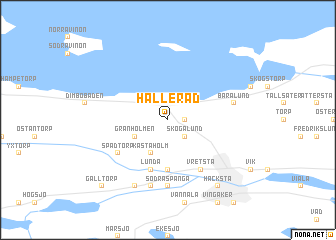
Hälleråd (Södermanland, Sweden)Hälleråd is a town in the Södermanland region of Sweden. An overview map of the region around Hälleråd is displayed below.
regional and 3d topo map of Hälleråd, Sweden ::
Hälleråd airports ::
The nearest airport is ORB - Orebro, located 46.1 km west of Hälleråd.
Other airports nearby include NRK - Norrkoeping Kungsangen (64.2 km south east), VST - Vasteras (70.2 km north east), NYO - Stockholm Skavsta (72.9 km south east), LPI - Linkoeping Saab (79.5 km south), Nearby towns ::
Läppe (1.9km north) //
Lindbol (1.0km east) //
Skogalund (2.1km south east) //
Granholmen (2.7km south west) //
Kåstaholm (3.8km south) //
Kåsta (5.6km south) //
Lunda (5.6km south) //
Vretsta (5.9km south) //
Spadtorp (4.7km south west) //
Nästorp (4.7km south west) //
Norra Spånga (7.4km south) //
Södra Spånga (7.4km south) //
Baralund (4.2km north east) //
Berga (7.5km south) //
Billsbro (7.7km south) //
Hacksta (7.9km south) //
Galltorp (8.3km south west) //
[all distances 'as the bird flies' and approximate] 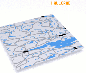 Places with similar names to Hälleråd, Sweden ::
Disclaimer :: Information on this page comes without warranty of any kind |
||
|
Where is Hälleråd? Elevation and coordinates ::
Latitude (lat): 59°7'0"N Longitude (lon): 15°49'0"E
Elevation (approx.): 60m (map arrows pan, magnifying glasses zoom) |
||
|
Visiting Hälleråd? Hotel/Accommodation ::
Book a hotel in Hälleråd Travel Guide ::
Buy a travel guide for Sweden rental cars ::
car rental offers GPS waypoint ::
download a GPX waypoint (PoI) of Hälleråd for your GPS receiver
|
||