|
search place name
|
||
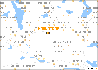
Härlatorp (Kronoberg, Sweden)Härlatorp is a town in the Kronoberg region of Sweden. An overview map of the region around Härlatorp is displayed below.
regional and 3d topo map of Härlatorp, Sweden ::
Härlatorp airports ::
The nearest airport is VXO - Vaxjo Kronoberg, located 17.7 km south east of Härlatorp.
Other airports nearby include JKG - Joenkoeping Jonkoping (87.7 km north), RNB - Ronneby (95.2 km south east), HLF - Hultsfred (100.7 km north east), HAD - Halmstad (106.2 km west), Nearby towns ::
Hakatorp (2.1km north west) //
Arnhult (2.1km north west) //
Tolestorp (3.7km north) //
Skövelåkra (3.8km north) //
Lusseboda (2.7km north west) //
Elofstorp (4.2km south east) //
Bråten (5.7km north) //
Kängshult (3.5km north west) //
Hössjö (3.5km north east) //
Skölstad (5.9km south) //
Klasentorp (4.8km north east) //
Bästerna (5.9km north) //
Kulla (5.9km north) //
Moheboda (7.4km north) //
Agnaryd (4.0km west) //
Mäxarp (4.4km south west) //
Kvenneberga (6.3km south east) //
Uråsa (5.5km south east) //
Transjö (7.7km south) //
Korsmon (5.5km south west) //
Käxås (5.5km north west) //
Hult (7.7km south) //
Vångsnäs (8.0km north) //
Vitteryd (8.4km north east) //
[all distances 'as the bird flies' and approximate] 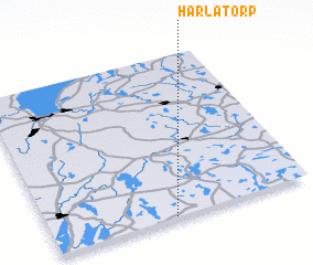 Places with similar names to Härlatorp, Sweden :: Disclaimer :: Information on this page comes without warranty of any kind |
||
|
Where is Härlatorp? Elevation and coordinates ::
Latitude (lat): 57°0'0"N Longitude (lon): 14°28'0"E
Elevation (approx.): 177m (map arrows pan, magnifying glasses zoom) |
||
|
Visiting Härlatorp? Hotel/Accommodation ::
Book a hotel in Härlatorp Travel Guide ::
Buy a travel guide for Sweden rental cars ::
car rental offers GPS waypoint ::
download a GPX waypoint (PoI) of Härlatorp for your GPS receiver
|
||