|
search place name
|
||
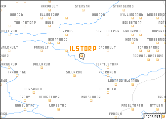
Ilstorp ((( Kristianstad )), Sweden)Ilstorp is a town in the (( Kristianstad )) region of Sweden. An overview map of the region around Ilstorp is displayed below.
regional and 3d topo map of Ilstorp, Sweden ::
Ilstorp airports ::
The nearest airport is KID - Kristianstad, located 21.4 km north east of Ilstorp.
Other airports nearby include MMX - Malmoe Sturup (43.0 km south west), JLD - Landskrona (70.1 km west), CPH - Copenhagen Kastrup (81.7 km west), RNN - Bornholm Ronne (92.7 km south east), Nearby towns ::
Trulshärad (2.1km north west) //
Sillaröd (3.9km south) //
Jönstorp (2.8km north west) //
Hemmeneköp (2.8km north west) //
Bertilstorp (3.6km south east) //
Grönhult (3.6km north east) //
Agusa (3.6km north east) //
Skärhus (5.9km north) //
Skäpperöd (4.8km north west) //
Andrarum (4.9km south east) //
Ribbetuaröd (6.4km north east) //
Slätteberga (6.4km north east) //
Långaröd (5.6km north west) //
Ludaröd (7.0km south east) //
Bontofta (8.0km south east) //
Buus (8.5km north west) //
[all distances 'as the bird flies' and approximate] 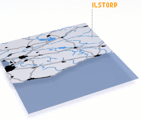 Places with similar names to Ilstorp, Sweden ::
// Ilstorp (SE)
Disclaimer :: Information on this page comes without warranty of any kind |
||
|
Where is Ilstorp? Elevation and coordinates ::
Latitude (lat): 55°45'0"N Longitude (lon): 13°56'0"E
Elevation (approx.): 150m (map arrows pan, magnifying glasses zoom) |
||
|
Visiting Ilstorp? Hotel/Accommodation ::
Book a hotel in Ilstorp Travel Guide ::
Buy a travel guide for Sweden rental cars ::
car rental offers GPS waypoint ::
download a GPX waypoint (PoI) of Ilstorp for your GPS receiver
|
||