|
search place name
|
||
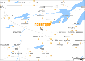
Ingestorp ((( Älvsborg )), Sweden)Ingestorp is a town in the (( Älvsborg )) region of Sweden. An overview map of the region around Ingestorp is displayed below.
regional and 3d topo map of Ingestorp, Sweden ::
Ingestorp airports ::
The nearest airport is JKG - Joenkoeping Jonkoping, located 53.8 km east of Ingestorp.
Other airports nearby include GOT - Gothenborg Landvetter (56.4 km west), GSE - Gothenborg Save (82.6 km west), THN - Trollhattan Vanersborg (95.2 km north west), LDK - Lidkoping (96.4 km north), Nearby towns ::
Länghem (1.0km east) //
Torstensered (2.1km north east) //
Bragnum (3.8km south) //
Svenstorp (3.8km south) //
Ömmesala (4.2km north east) //
Holm (4.2km south east) //
Fägerhult (5.6km north) //
Broaslätt (5.6km south) //
Varred (3.5km south east) //
Grälåsa (5.9km south) //
Jättebo (7.4km north) //
Läggared (4.4km north west) //
Hovsnäs (5.4km north east) //
Kvigärde (5.4km north west) //
Hillared (5.4km north west) //
Gästarp (6.8km south east) //
Grimmared (8.4km south east) //
[all distances 'as the bird flies' and approximate] 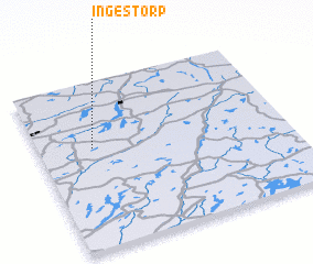 Places with similar names to Ingestorp, Sweden :: Disclaimer :: Information on this page comes without warranty of any kind |
||
|
Where is Ingestorp? Elevation and coordinates ::
Latitude (lat): 57°36'0"N Longitude (lon): 13°13'0"E
Elevation (approx.): 196m (map arrows pan, magnifying glasses zoom) |
||
|
Visiting Ingestorp? Hotel/Accommodation ::
Book a hotel in Ingestorp Travel Guide ::
Buy a travel guide for Sweden rental cars ::
car rental offers GPS waypoint ::
download a GPX waypoint (PoI) of Ingestorp for your GPS receiver
|
||