|
search place name
|
||
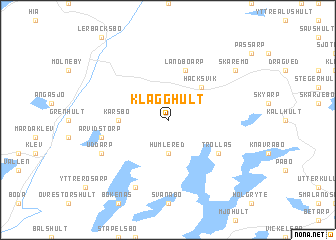
Klägghult ((( Älvsborg )), Sweden)Klägghult is a town in the (( Älvsborg )) region of Sweden. An overview map of the region around Klägghult is displayed below.
regional and 3d topo map of Klägghult, Sweden ::
Klägghult airports ::
The nearest airport is GOT - Gothenborg Landvetter, located 65.6 km north west of Klägghult.
Other airports nearby include HAD - Halmstad (68.4 km south), JKG - Joenkoeping Jonkoping (77.7 km north east), GSE - Gothenborg Save (92.6 km north west), VXO - Vaxjo Kronoberg (105.3 km east), Nearby towns ::
Humlered (3.7km south) //
Håcksvik (4.2km north east) //
Karsbo (3.0km west) //
Landboarp (5.6km north) //
Trollås (4.8km south east) //
Arvidstorp (4.4km south west) //
Lommaholmen (7.7km south) //
Uddarp (5.5km south west) //
Skäremo (6.9km north east) //
[all distances 'as the bird flies' and approximate] 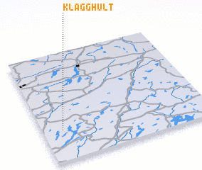 Places with similar names to Klägghult, Sweden ::
// Kelgouli Adia (TD)
// Koulkoulto (SN)
// Collique Alto (PE)
// Galgaldu (NG)
// Kʼeley Kohlīt (ET)
// Kʼelkʼeltī (ET)
// Collique Alto (PE)
Disclaimer :: Information on this page comes without warranty of any kind |
||
|
Where is Klägghult? Elevation and coordinates ::
Latitude (lat): 57°17'0"N Longitude (lon): 13°7'0"E
Elevation (approx.): 142m (map arrows pan, magnifying glasses zoom) |
||
|
Visiting Klägghult? Hotel/Accommodation ::
Book a hotel in Klägghult Travel Guide ::
Buy a travel guide for Sweden rental cars ::
car rental offers GPS waypoint ::
download a GPX waypoint (PoI) of Klägghult for your GPS receiver
|
||