|
search place name
|
||
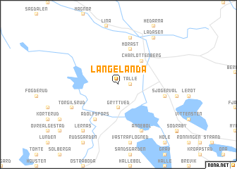
Långelanda (Värmland, Sweden)Långelanda is a town in the Värmland region of Sweden. An overview map of the region around Långelanda is displayed below.
regional and 3d topo map of Långelanda, Sweden ::
Långelanda airports ::
The nearest airport is OSL - Oslo Gardermoen, located 74.7 km north west of Långelanda.
Other airports nearby include TRF - Torp (134.8 km south west), LDK - Lidkoping (163.0 km south), THN - Trollhattan Vanersborg (170.7 km south), KVB - Skovde (183.9 km south east), Nearby towns ::
Tälle (0.9km east) //
Gryttved (3.7km south) //
Charlottenberg (4.1km north east) //
Morast (5.6km north) //
Adolfsfors (5.9km south) //
Eda Glasbruk (7.5km north) //
Haga (4.2km south east) //
Sjögervål (4.2km south east) //
Mellbyn (4.2km south east) //
Eda (4.2km south east) //
Ånnebol (7.6km south) //
Torgilsrud (5.3km south west) //
Lernäs (7.9km south) //
Ladåsen (7.9km north) //
[all distances 'as the bird flies' and approximate] 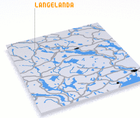 Places with similar names to Långelanda, Sweden ::
Disclaimer :: Information on this page comes without warranty of any kind |
||
|
Where is Långelanda? Elevation and coordinates ::
Latitude (lat): 59°51'0"N Longitude (lon): 12°15'0"E
Elevation (approx.): 126m (map arrows pan, magnifying glasses zoom) |
||
|
Visiting Långelanda? Hotel/Accommodation ::
Book a hotel in Långelanda Travel Guide ::
Buy a travel guide for Sweden rental cars ::
car rental offers GPS waypoint ::
download a GPX waypoint (PoI) of Långelanda for your GPS receiver
|
||