|
search place name
|
||
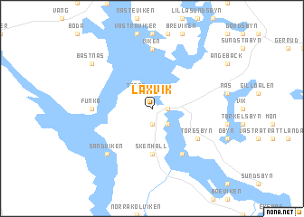
Laxvik (Värmland, Sweden)Laxvik is a town in the Värmland region of Sweden. An overview map of the region around Laxvik is displayed below.
regional and 3d topo map of Laxvik, Sweden ::
Laxvik airports ::
The nearest airport is TRF - Torp, located 94.8 km west of Laxvik.
Other airports nearby include OSL - Oslo Gardermoen (107.6 km north west), THN - Trollhattan Vanersborg (114.2 km south), LDK - Lidkoping (119.9 km south east), GSE - Gothenborg Save (171.8 km south), Nearby towns ::
Lennartsfors (0.9km east) //
Källsbyn (1.9km south) //
Gunnarsbyn (1.9km south) //
Trane (2.1km north west) //
Södra Viker (2.1km south east) //
Norra Viker (2.1km south east) //
Skenhall (5.6km south) //
Gyltenäs (5.9km south) //
Blomma (4.7km south east) //
Töresbyn (4.7km south east) //
Viken (7.4km north) //
Funka (3.8km west) //
Sandviken (6.2km south west) //
Båstnäs (6.7km north west) //
[all distances 'as the bird flies' and approximate] 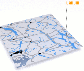
Disclaimer :: Information on this page comes without warranty of any kind |
||
|
Where is Laxvik? Elevation and coordinates ::
Latitude (lat): 59°19'0"N Longitude (lon): 11°54'0"E
Elevation (approx.): 114m (map arrows pan, magnifying glasses zoom) |
||
|
Visiting Laxvik? Hotel/Accommodation ::
Book a hotel in Laxvik Travel Guide ::
Buy a travel guide for Sweden rental cars ::
car rental offers GPS waypoint ::
download a GPX waypoint (PoI) of Laxvik for your GPS receiver
|
||