|
search place name
|
||
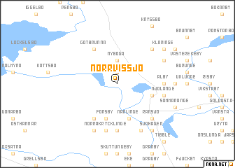
Norrvissjö (Uppsala, Sweden)Norrvissjö is a town in the Uppsala region of Sweden. An overview map of the region around Norrvissjö is displayed below.
regional and 3d topo map of Norrvissjö, Sweden ::
Norrvissjö airports ::
The nearest airport is ARN - Stockholm Arlanda, located 55.1 km south east of Norrvissjö.
Other airports nearby include GVX - Gavle (62.8 km north west), VST - Vasteras (74.8 km south west), BMA - Stockholm Bromma (86.7 km south), BLE - Borlange (115.6 km west), Nearby towns ::
Tolboda (1.9km north) //
Nyboda (3.7km north) //
Läby (3.3km south east) //
Närlinge (5.6km south) //
Forsby (5.6km south) //
Långåker (5.6km south) //
Götbrunna (5.9km north) //
Axlunda (5.9km south) //
Älby (3.7km east) //
Brunnby (7.4km south) //
Norra Krycklinge (7.5km south) //
Mjölänge (4.1km south east) //
Hökby (6.2km north east) //
Ramsjö (6.2km south east) //
Gryttby (5.2km north east) //
Hammarby (7.6km south) //
Häggeby (7.6km south) //
Kläringe (6.7km north east) //
Husby (6.7km north east) //
Sjöhagen (7.9km south) //
Björklinge (7.9km south) //
[all distances 'as the bird flies' and approximate]  Places with similar names to Norrvissjö, Sweden :: Disclaimer :: Information on this page comes without warranty of any kind |
||
|
Where is Norrvissjö? Elevation and coordinates ::
Latitude (lat): 60°6'0"N Longitude (lon): 17°30'0"E
(map arrows pan, magnifying glasses zoom) |
||
|
Visiting Norrvissjö? Hotel/Accommodation ::
Book a hotel in Norrvissjö Travel Guide ::
Buy a travel guide for Sweden rental cars ::
car rental offers GPS waypoint ::
download a GPX waypoint (PoI) of Norrvissjö for your GPS receiver
|
||