|
search place name
|
||
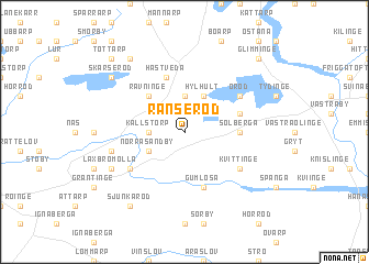
Ranseröd ((( Kristianstad )), Sweden)Ranseröd is a town in the (( Kristianstad )) region of Sweden. An overview map of the region around Ranseröd is displayed below.
regional and 3d topo map of Ranseröd, Sweden ::
Ranseröd airports ::
The nearest airport is KID - Kristianstad, located 33.9 km south of Ranseröd.
Other airports nearby include JLD - Landskrona (73.8 km south west), RNB - Ronneby (81.7 km east), MMX - Malmoe Sturup (84.6 km south west), HAD - Halmstad (87.4 km north west), Nearby towns ::
Källstorp (2.1km west) //
Askustorp (3.7km north) //
Norra Sandby (2.8km south west) //
Hylhult (3.8km north) //
Rävninge (4.2km north west) //
Solberga (3.1km east) //
Tryggaröd (3.6km north east) //
Gumlösa (5.7km south) //
Hästveda (5.7km north) //
Oröd (4.8km north east) //
Fjärlöv (4.8km south west) //
Kvittinge (4.8km south east) //
Aska (4.5km south west) //
Laxbromölla (5.5km south west) //
Påarp (8.0km north west) //
Sjunkaröd (8.0km south west) //
Skärseröd (6.9km north west) //
Tottarp (8.5km north west) //
Glimminge (8.5km north east) //
[all distances 'as the bird flies' and approximate] 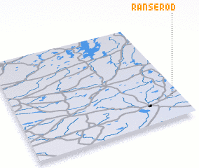 Places with similar names to Ranseröd, Sweden ::
Disclaimer :: Information on this page comes without warranty of any kind |
||
|
Where is Ranseröd? Elevation and coordinates ::
Latitude (lat): 56°13'0"N Longitude (lon): 13°57'0"E
Elevation (approx.): 62m (map arrows pan, magnifying glasses zoom) |
||
|
Visiting Ranseröd? Hotel/Accommodation ::
Book a hotel in Ranseröd Travel Guide ::
Buy a travel guide for Sweden rental cars ::
car rental offers GPS waypoint ::
download a GPX waypoint (PoI) of Ranseröd for your GPS receiver
|
||