|
search place name
|
||
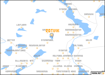
Rotvik (Värmland, Sweden)Rotvik is a town in the Värmland region of Sweden. An overview map of the region around Rotvik is displayed below.
regional and 3d topo map of Rotvik, Sweden ::
Rotvik airports ::
The nearest airport is KSK - Karlskoga, located 100.3 km east of Rotvik.
Other airports nearby include LDK - Lidkoping (101.8 km south), THN - Trollhattan Vanersborg (117.1 km south), KVB - Skovde (122.5 km south east), OSL - Oslo Gardermoen (131.4 km north west), Nearby towns ::
Stenarsbol (2.1km south west) //
Spelerud (2.1km north west) //
Speke (2.1km north west) //
Häljebol (3.4km north east) //
Nedre Kålsäter (4.7km south west) //
Nysäter (5.9km south) //
Fyxnäs (3.8km east) //
Södra Högsäter (3.8km east) //
Rolfsbol (7.5km south) //
Norra Högsäter (4.2km north east) //
Magnebyn (5.3km north east) //
Ökne (7.7km south) //
Backa (7.9km south) //
Granbäck (7.9km south) //
[all distances 'as the bird flies' and approximate] 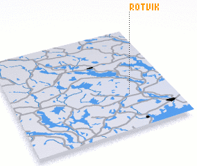 Places with similar names to Rotvik, Sweden ::
Disclaimer :: Information on this page comes without warranty of any kind |
||
|
Where is Rotvik? Elevation and coordinates ::
Latitude (lat): 59°21'0"N Longitude (lon): 12°44'0"E
Elevation (approx.): 113m (map arrows pan, magnifying glasses zoom) |
||
|
Visiting Rotvik? Hotel/Accommodation ::
Book a hotel in Rotvik Travel Guide ::
Buy a travel guide for Sweden rental cars ::
car rental offers GPS waypoint ::
download a GPX waypoint (PoI) of Rotvik for your GPS receiver
|
||