|
search place name
|
||
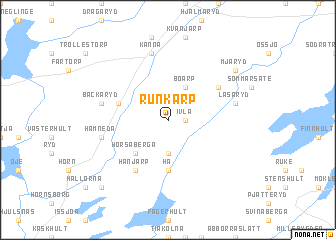
Runkarp (Kronoberg, Sweden)Runkarp is a town in the Kronoberg region of Sweden. An overview map of the region around Runkarp is displayed below.
regional and 3d topo map of Runkarp, Sweden ::
Runkarp airports ::
The nearest airport is VXO - Vaxjo Kronoberg, located 54.9 km north east of Runkarp.
Other airports nearby include HAD - Halmstad (67.2 km west), KID - Kristianstad (89.1 km south), RNB - Ronneby (97.0 km south east), JLD - Landskrona (107.7 km south west), Nearby towns ::
Ivla (1.0km east) //
Fageryd (3.7km south) //
Björstorp (3.7km south) //
Boarp (3.8km north) //
Horsaberga (4.2km south west) //
Hå (5.6km south) //
Bäck (3.6km north west) //
Södra Ljunga (4.8km north east) //
Hänjarp (5.9km south) //
Läsaryd (4.5km north east) //
Kånna (7.5km north) //
Bäckaryd (4.5km north west) //
Elinge (4.5km south west) //
Hamneda (4.5km south west) //
Mjäryd (6.9km north east) //
Bohok (8.5km south west) //
[all distances 'as the bird flies' and approximate] 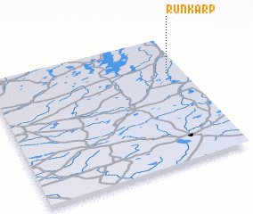 Places with similar names to Runkarp, Sweden :: Disclaimer :: Information on this page comes without warranty of any kind |
||
|
Where is Runkarp? Elevation and coordinates ::
Latitude (lat): 56°43'0"N Longitude (lon): 13°55'0"E
Elevation (approx.): 153m (map arrows pan, magnifying glasses zoom) |
||
|
Visiting Runkarp? Hotel/Accommodation ::
Book a hotel in Runkarp Travel Guide ::
Buy a travel guide for Sweden rental cars ::
car rental offers GPS waypoint ::
download a GPX waypoint (PoI) of Runkarp for your GPS receiver
|
||