|
search place name
|
||
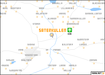
Säterkullen ((( Älvsborg )), Sweden)Säterkullen is a town in the (( Älvsborg )) region of Sweden. An overview map of the region around Säterkullen is displayed below.
regional and 3d topo map of Säterkullen, Sweden ::
Säterkullen airports ::
The nearest airport is KVB - Skovde, located 4.2 km north east of Säterkullen.
Other airports nearby include LDK - Lidkoping (43.5 km west), JKG - Joenkoeping Jonkoping (75.8 km south), THN - Trollhattan Vanersborg (92.8 km west), LPI - Linkoeping Saab (103.1 km east), Nearby towns ::
Ulvåker (5.6km north) //
Forsby (5.6km south) //
Öm (5.6km south) //
Igelstorp (4.7km south east) //
Stöpen (4.7km north west) //
Locketorp (5.9km north) //
Mårum (7.5km north) //
Locketorp (6.3km north east) //
Skövde (5.3km south west) //
Bränningen (5.4km north east) //
Väring (7.7km north) //
Häljatorp (7.7km north) //
Myreberg (6.8km north east) //
Stora Väring (8.0km north) //
Truvet (8.0km north) //
Frösve (8.0km north) //
Segerstorp (8.3km south west) //
[all distances 'as the bird flies' and approximate] 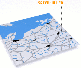 Places with similar names to Säterkullen, Sweden ::
// Cedar Glen (US)
// Stare Kolnie (PL)
// Stara Kul'na (UA)
// Starý Kolín (CZ)
// Stora Kilane (SE)
// Stora Ykullen (SE)
// Sutarekullen (SE)
// Zuiderkolonie (NL)
Disclaimer :: Information on this page comes without warranty of any kind |
||
|
Where is Säterkullen? Elevation and coordinates ::
Latitude (lat): 58°25'59"N Longitude (lon): 13°55'0"E
Elevation (approx.): 119m (map arrows pan, magnifying glasses zoom) |
||
|
Visiting Säterkullen? Hotel/Accommodation ::
Book a hotel in Säterkullen Travel Guide ::
Buy a travel guide for Sweden rental cars ::
car rental offers GPS waypoint ::
download a GPX waypoint (PoI) of Säterkullen for your GPS receiver
|
||