|
search place name
|
||
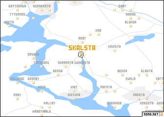
Skålsta (Stockholm, Sweden)Skålsta is a town in the Stockholm region of Sweden. An overview map of the region around Skålsta is displayed below.
regional and 3d topo map of Skålsta, Sweden ::
nearby GPS traces from timatio ::
Skålsta airports ::
The nearest airport is ARN - Stockholm Arlanda, located 11.7 km south east of Skålsta.
Other airports nearby include BMA - Stockholm Bromma (40.3 km south), VST - Vasteras (63.2 km west), GVX - Gavle (108.6 km north west), NYO - Stockholm Skavsta (111.8 km south west), Nearby towns ::
Gurresta (1.9km south) //
Årby (3.7km north) //
Skråmsta (2.6km south west) //
Alsike (5.6km north) //
Ärlinghundra Härad (4.6km south east) //
Berga (4.6km south west) //
Vrå (5.9km north) //
Viby (7.5km south) //
Knivsta (4.2km north east) //
Räfsta (7.9km south) //
Droppsta (8.3km south east) //
[all distances 'as the bird flies' and approximate]  Places with similar names to Skålsta, Sweden ::
// Sokolište (BA)
// Sokolište (BA)
// Cioculeşti (RO)
// Ciuculeşti (RO)
// Ciuculeşti (RO)
// Schiuleşti (RO)
// Seculeşti (RO)
// Schell City (US)
// Zogolzot (ET)
// Sickelsta (SE)
Disclaimer :: Information on this page comes without warranty of any kind |
||
|
Where is Skålsta? Elevation and coordinates ::
Latitude (lat): 59°42'0"N Longitude (lon): 17°44'0"E
Elevation (approx.): 8m (map arrows pan, magnifying glasses zoom) |
||
|
Visiting Skålsta? Hotel/Accommodation ::
Book a hotel in Skålsta Travel Guide ::
Buy a travel guide for Sweden rental cars ::
car rental offers GPS waypoint ::
download a GPX waypoint (PoI) of Skålsta for your GPS receiver
|
||