|
search place name
|
||
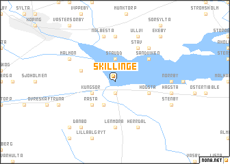
Skillinge (Västmanland, Sweden)Skillinge is a town in the Västmanland region of Sweden. An overview map of the region around Skillinge is displayed below.
regional and 3d topo map of Skillinge, Sweden ::
Skillinge airports ::
The nearest airport is VST - Vasteras, located 34.0 km north east of Skillinge.
Other airports nearby include ORB - Orebro (65.7 km west), NYO - Stockholm Skavsta (85.1 km south east), KSK - Karlskoga (92.6 km west), NRK - Norrkoeping Kungsangen (94.7 km south), Nearby towns ::
Malmberga (1.9km south) //
Stäudd (3.7km north) //
Dammen (3.8km south) //
Kungsör (2.6km south west) //
Råsta (4.2km south west) //
Högsta (3.4km south east) //
Himmelsberga (3.4km south east) //
Jägaråsen (3.4km north west) //
Stav (5.9km north) //
Sandviken (4.7km north east) //
Lenmora (7.4km south) //
Hogsta (7.4km north) //
Nalbesta (7.5km north) //
Dåvö (6.2km north east) //
Herrdal (7.6km south) //
Ullvi (7.6km north) //
Malmön (5.3km north west) //
Danbo (7.9km south) //
Aspesten (8.3km south west) //
Ekeby (8.3km north east) //
[all distances 'as the bird flies' and approximate] 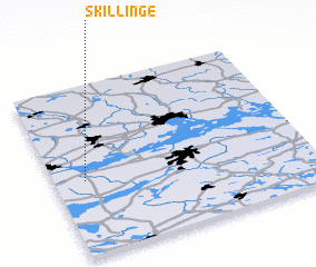 Places with similar names to Skillinge, Sweden ::
Disclaimer :: Information on this page comes without warranty of any kind |
||
|
Where is Skillinge? Elevation and coordinates ::
Latitude (lat): 59°26'0"N Longitude (lon): 16°7'0"E
Elevation (approx.): 3m (map arrows pan, magnifying glasses zoom) |
||
|
Visiting Skillinge? Hotel/Accommodation ::
Book a hotel in Skillinge Travel Guide ::
Buy a travel guide for Sweden rental cars ::
car rental offers GPS waypoint ::
download a GPX waypoint (PoI) of Skillinge for your GPS receiver
|
||