|
search place name
|
||
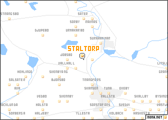
Ståltorp (Västmanland, Sweden)Ståltorp is a town in the Västmanland region of Sweden. An overview map of the region around Ståltorp is displayed below.
regional and 3d topo map of Ståltorp, Sweden ::
Ståltorp airports ::
The nearest airport is VST - Vasteras, located 27.5 km east of Ståltorp.
Other airports nearby include ORB - Orebro (82.7 km south west), BLE - Borlange (90.3 km north west), ARN - Stockholm Arlanda (97.9 km east), KSK - Karlskoga (102.7 km west), Nearby towns ::
Olberga (0.9km east) //
Tackfallet (2.1km south west) //
Jobsbo (1.9km west) //
Vallhall (2.6km south west) //
Surahammar (4.2km north east) //
Urmakarbo (5.6km north) //
Trångfors (5.6km south) //
Svenbyäng (4.7km south west) //
Åsby (7.5km south) //
Skansen (7.5km south) //
Sörby (7.5km north) //
Rävnäs (7.5km north) //
Björsbo (6.2km south west) //
Hallstahammar (7.6km south) //
Östtuna (7.9km south) //
Tuna (7.9km south) //
[all distances 'as the bird flies' and approximate] 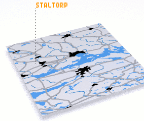 Places with similar names to Ståltorp, Sweden ::
// Stalltorp (SE)
Disclaimer :: Information on this page comes without warranty of any kind |
||
|
Where is Ståltorp? Elevation and coordinates ::
Latitude (lat): 59°41'0"N Longitude (lon): 16°11'0"E
Elevation (approx.): 65m (map arrows pan, magnifying glasses zoom) |
||
|
Visiting Ståltorp? Hotel/Accommodation ::
Book a hotel in Ståltorp Travel Guide ::
Buy a travel guide for Sweden rental cars ::
car rental offers GPS waypoint ::
download a GPX waypoint (PoI) of Ståltorp for your GPS receiver
|
||