|
search place name
|
||
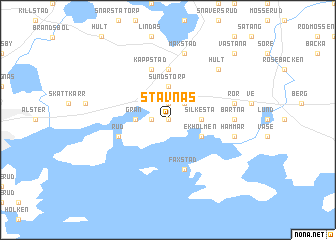
Stavnäs (Värmland, Sweden)Stavnäs is a town in the Värmland region of Sweden. An overview map of the region around Stavnäs is displayed below.
regional and 3d topo map of Stavnäs, Sweden ::
Stavnäs airports ::
The nearest airport is KSK - Karlskoga, located 43.8 km east of Stavnäs.
Other airports nearby include ORB - Orebro (76.9 km east), KVB - Skovde (106.0 km south), LDK - Lidkoping (108.9 km south), THN - Trollhattan Vanersborg (144.7 km south west), Nearby towns ::
Rörsvik (0.0km north east) //
Kärne (0.9km west) //
Östra Fågelvik (1.9km north) //
Vång (2.1km north east) //
Grän (1.9km west) //
Sundstorp (3.7km north) //
Averstad (3.7km north) //
Bäck (3.7km north) //
Silkesta (1.9km east) //
Ekholmen (2.6km south east) //
Bög (5.6km north) //
Rud (3.4km south west) //
Faxstad (5.6km south) //
Kappstad (5.7km north) //
Bartna (3.8km east) //
Hammar (4.2km south east) //
Rör (4.2km north east) //
Maxstad (7.5km north) //
Bregården (7.5km north) //
Hult (6.3km north east) //
Västanå (8.4km north east) //
Motorp (8.4km north east) //
[all distances 'as the bird flies' and approximate] 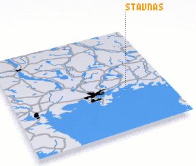 Places with similar names to Stavnäs, Sweden ::
Disclaimer :: Information on this page comes without warranty of any kind |
||
|
Where is Stavnäs? Elevation and coordinates ::
Latitude (lat): 59°23'59"N Longitude (lon): 13°43'59"E
Elevation (approx.): 61m (map arrows pan, magnifying glasses zoom) |
||
|
Visiting Stavnäs? Hotel/Accommodation ::
Book a hotel in Stavnäs Travel Guide ::
Buy a travel guide for Sweden rental cars ::
car rental offers GPS waypoint ::
download a GPX waypoint (PoI) of Stavnäs for your GPS receiver
|
||