|
search place name
|
||
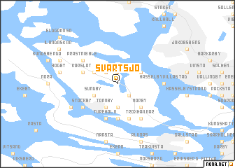
Svartsjö (Stockholm, Sweden)Svartsjö is a town in the Stockholm region of Sweden. An overview map of the region around Svartsjö is displayed below.
regional and 3d topo map of Svartsjö, Sweden ::
Svartsjö airports ::
The nearest airport is BMA - Stockholm Bromma, located 11.9 km east of Svartsjö.
Other airports nearby include ARN - Stockholm Arlanda (33.5 km north), VST - Vasteras (67.1 km west), NYO - Stockholm Skavsta (79.8 km south west), NRK - Norrkoeping Kungsangen (121.8 km south west), Nearby towns ::
Ricksättra (1.8km north) //
Viksund (2.1km north west) //
Kumla (2.1km south east) //
Skå (3.7km south) //
Hillersjö (2.6km north west) //
Sundby (2.6km south west) //
Sockarby (2.6km south west) //
Färjstaden (2.6km north east) //
Törnby (3.8km south) //
Mörby (4.2km south east) //
Säby (5.6km south) //
Eneby (5.6km south) //
Söderberga (5.6km south) //
Korslöt (3.4km north west) //
Tureholm (5.6km south) //
Berga (5.6km south) //
Prästnibble (4.7km north west) //
Troxhammar (5.9km south) //
Stockby (4.7km south west) //
Hässelby Villastad (3.8km east) //
Stenhamra (5.3km south west) //
[all distances 'as the bird flies' and approximate] 
Disclaimer :: Information on this page comes without warranty of any kind |
||
|
Where is Svartsjö? Elevation and coordinates ::
Latitude (lat): 59°22'0"N Longitude (lon): 17°44'0"E
Elevation (approx.): 6m (map arrows pan, magnifying glasses zoom) |
||
|
Visiting Svartsjö? Hotel/Accommodation ::
Book a hotel in Svartsjö Travel Guide ::
Buy a travel guide for Sweden rental cars ::
car rental offers GPS waypoint ::
download a GPX waypoint (PoI) of Svartsjö for your GPS receiver
|
||