|
search place name
|
||
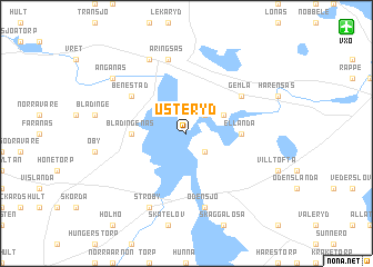
Usteryd (Kronoberg, Sweden)Usteryd is a town in the Kronoberg region of Sweden. An overview map of the region around Usteryd is displayed below.
regional and 3d topo map of Usteryd, Sweden ::
Usteryd airports ::
The nearest airport is VXO - Vaxjo Kronoberg, located 13.8 km north east of Usteryd.
Other airports nearby include RNB - Ronneby (75.8 km south east), KLR - Kalkmar Kalmar (105.5 km east), KID - Kristianstad (106.1 km south), JKG - Joenkoeping Jonkoping (107.5 km north), Nearby towns ::
Törnåkra (2.1km south east) //
Gransholm (2.1km north east) //
Öppestorp (2.1km north east) //
Öja (2.7km north east) //
Blädingenäs (3.0km west) //
Ellanda (3.0km east) //
Benestad (4.8km north west) //
Getaskärv (4.8km north east) //
Gemla (4.8km north east) //
Odensjö (7.5km south) //
Aringsås (7.5km north) //
Ströby (7.7km south) //
Alvesta (7.7km north) //
Änganäs (6.9km north west) //
[all distances 'as the bird flies' and approximate] 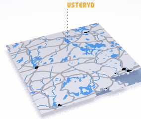 Places with similar names to Usteryd, Sweden :: Disclaimer :: Information on this page comes without warranty of any kind |
||
|
Where is Usteryd? Elevation and coordinates ::
Latitude (lat): 56°50'0"N Longitude (lon): 14°35'0"E
Elevation (approx.): 161m (map arrows pan, magnifying glasses zoom) |
||
|
Visiting Usteryd? Hotel/Accommodation ::
Book a hotel in Usteryd Travel Guide ::
Buy a travel guide for Sweden rental cars ::
car rental offers GPS waypoint ::
download a GPX waypoint (PoI) of Usteryd for your GPS receiver
|
||