|
search place name
|
||
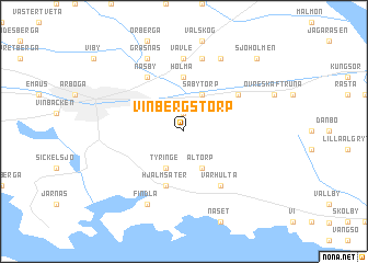
Vinbergstorp (Västmanland, Sweden)Vinbergstorp is a town in the Västmanland region of Sweden. An overview map of the region around Vinbergstorp is displayed below.
regional and 3d topo map of Vinbergstorp, Sweden ::
Vinbergstorp airports ::
The nearest airport is VST - Vasteras, located 46.8 km north east of Vinbergstorp.
Other airports nearby include ORB - Orebro (53.4 km west), KSK - Karlskoga (81.8 km west), NYO - Stockholm Skavsta (85.4 km south east), NRK - Norrkoeping Kungsangen (88.8 km south), Nearby towns ::
Hällby (1.9km north) //
Säby (1.9km north) //
Säbytorp (3.8km north) //
Tyringe (3.8km south) //
Åltorp (3.8km south) //
Marieberg (3.8km south) //
Aspa (5.6km north) //
Holma (5.6km north) //
Hjälmsäter (5.6km south) //
Näsby (5.9km north) //
Nedre Skäftruna (4.7km north east) //
Värhulta (5.9km south) //
Vavle (7.4km north) //
Lådberga (7.5km north) //
Berg (7.5km north) //
Gräsnäs (7.6km north) //
Segelsberga (7.6km north) //
Findla (7.7km south) //
Sjöholmen (8.3km north east) //
[all distances 'as the bird flies' and approximate]  Places with similar names to Vinbergstorp, Sweden :: Disclaimer :: Information on this page comes without warranty of any kind |
||
|
Where is Vinbergstorp? Elevation and coordinates ::
Latitude (lat): 59°22'0"N Longitude (lon): 15°56'0"E
Elevation (approx.): 65m (map arrows pan, magnifying glasses zoom) |
||
|
Visiting Vinbergstorp? Hotel/Accommodation ::
Book a hotel in Vinbergstorp Travel Guide ::
Buy a travel guide for Sweden rental cars ::
car rental offers GPS waypoint ::
download a GPX waypoint (PoI) of Vinbergstorp for your GPS receiver
|
||