|
search place name
|
||
Brännskiftet (Länsi-Suomen Lääni, Finland)Brännskiftet is a town in the Länsi-Suomen Lääni region of Finland. An overview map of the region around Brännskiftet is displayed below.
regional and 3d topo map of Brännskiftet, Finland ::

Brännskiftet airports ::
The nearest airport is VAA - Vaasa, located 40.3 km north of Brännskiftet.
Other airports nearby include KAU - Kauhava (89.2 km north east), UME - Umea (137.7 km north west), POR - Pori (138.5 km south), KOK - Kruunupyy (138.7 km north east), Nearby towns ::
Brännbacken (0.9km east) //
Söder i Byn (0.9km east) //
Arstu (2.0km south west) //
Pörtbäcken (2.0km south west) //
Hag (2.5km north east) //
Bränngårdarna (3.8km south) //
Långback (2.5km south east) //
Granliden (4.1km south west) //
Pörtmossen (4.1km south west) //
Piparsidan (2.6km east) //
Pirttikylä (2.6km east) //
Sommarback (2.6km east) //
Mattlars (2.6km east) //
Pörtom (2.6km east) //
Källmossen (5.6km south) //
Öster i Byn (3.4km east) //
Pellasback (3.9km north east) //
Rainebäck (7.5km north) //
Västerback (6.1km north east) //
Dalbacken (5.0km north east) //
Berga (5.0km north east) //
Norrback (6.5km north east) //
Valsås (8.2km south east) //
[all distances 'as the bird flies' and approximate] 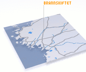 Places with similar names to Brännskiftet, Finland :: Disclaimer :: Information on this page comes without warranty of any kind |
||
|
Where is Brännskiftet? Elevation and coordinates ::
Latitude (lat): 62°42'0"N Longitude (lon): 21°34'0"E
(map arrows pan, magnifying glasses zoom) |
||
|
Visiting Brännskiftet? Hotel/Accommodation ::
Book a hotel in Brännskiftet Travel Guide ::
Buy a travel guide for Finland rental cars ::
car rental offers GPS waypoint ::
download a GPX waypoint (PoI) of Brännskiftet for your GPS receiver
|
||