|
search place name
|
||
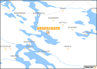
Haapavaara (Itä-Suomen Lääni, Finland)Haapavaara is a town in the Itä-Suomen Lääni region of Finland. An overview map of the region around Haapavaara is displayed below.
regional and 3d topo map of Haapavaara, Finland ::
Haapavaara airports ::
The nearest airport is JOE - Joensuu, located 84.4 km west of Haapavaara.
Nearby towns ::
Rotila (0.0km north) //
Rajavaara (5.6km north) //
Anttila (4.5km north east) //
Melasel'kya (7.5km south) //
Nehvonniemi (5.0km south west) //
Oinaansalmi (7.6km north) //
Sonnila (6.5km south west) //
Ollila (6.5km south west) //
Purola (6.5km south east) //
[all distances 'as the bird flies' and approximate] 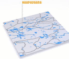 Places with similar names to Haapavaara, Finland ::
// Hopferau (DE)
// Haapavaara (FI)
// Haapavaara (FI)
// Haapavaara (FI)
// Haapavaara (FI)
// Haapavaara (FI)
// Haapavaara (FI)
// Haapovaara (FI)
Disclaimer :: Information on this page comes without warranty of any kind |
||
|
Where is Haapavaara? Elevation and coordinates ::
Latitude (lat): 62°33'0"N Longitude (lon): 31°14'0"E
(map arrows pan, magnifying glasses zoom) |
||
|
Visiting Haapavaara? Hotel/Accommodation ::
Book a hotel in Haapavaara Travel Guide ::
Buy a travel guide for Finland rental cars ::
car rental offers GPS waypoint ::
download a GPX waypoint (PoI) of Haapavaara for your GPS receiver
|
||