|
search place name
|
||
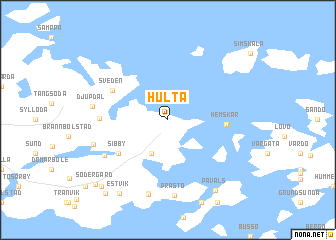
Hulta (Ahvenanmaa, Finland)Hulta is a town in the Ahvenanmaa region of Finland. An overview map of the region around Hulta is displayed below.
regional and 3d topo map of Hulta, Finland ::
Hulta airports ::
The nearest airport is MHQ - Mariehamn, located 26.5 km south west of Hulta.
Other airports nearby include POR - Pori (156.0 km north east), Nearby towns ::
Mångstäkta (3.8km south) //
Hemskär (3.3km east) //
Sibby (4.6km south west) //
Sveden (4.5km north west) //
Kleven (3.8km west) //
Persby (5.3km south west) //
Prästö (8.4km south) //
Djupdal (4.4km west) //
Bomarsund (8.3km south) //
Bomarsund (8.3km south) //
Strömbolstad (4.9km south west) //
Påvals (8.3km south) //
Estvik (8.6km south) //
Finby (8.3km south west) //
Mattas (8.9km south west) //
Södergård (8.2km south west) //
[all distances 'as the bird flies' and approximate]  Places with similar names to Hulta, Finland ::
Disclaimer :: Information on this page comes without warranty of any kind |
||
|
Where is Hulta? Elevation and coordinates ::
Latitude (lat): 60°17'0"N Longitude (lon): 20°15'0"E
(map arrows pan, magnifying glasses zoom) |
||
|
Visiting Hulta? Hotel/Accommodation ::
Book a hotel in Hulta Travel Guide ::
Buy a travel guide for Finland rental cars ::
car rental offers GPS waypoint ::
download a GPX waypoint (PoI) of Hulta for your GPS receiver
|
||