|
search place name
|
||
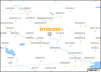
Pitkäkoski (Etelä-Suomen Lääni, Finland)Pitkäkoski is a town in the Etelä-Suomen Lääni region of Finland. An overview map of the region around Pitkäkoski is displayed below.
regional and 3d topo map of Pitkäkoski, Finland ::
Pitkäkoski airports ::
The nearest airport is QVY - Utti, located 44.2 km north west of Pitkäkoski.
Other airports nearby include LPP - Lappeenranta (51.5 km north east), MIK - Mikkeli (115.7 km north), SVL - Savonlinna (159.4 km north east), VRK - Varkaus (168.3 km north), Nearby towns ::
Kylmälä (1.8km east) //
Kalliokoski (2.6km north west) //
Yläkäs (2.6km south west) //
Kummikorpi (4.1km north west) //
Hirvisaarenkulma (4.1km south west) //
Karvistonpuoli (5.6km north) //
Säkäjärvi (5.6km south) //
Mässelinmaki (5.6km south) //
Suur-Miehikkälä (5.6km north) //
Huoppi (3.6km west) //
Rongas (3.6km west) //
Nippula (4.1km south west) //
Saareksi (7.6km north) //
Ihalainen (5.2km south east) //
Kantola (6.6km north west) //
[all distances 'as the bird flies' and approximate] 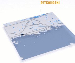 Places with similar names to Pitkäkoski, Finland ::
Disclaimer :: Information on this page comes without warranty of any kind |
||
|
Where is Pitkäkoski? Elevation and coordinates ::
Latitude (lat): 60°40'0"N Longitude (lon): 27°36'0"E
(map arrows pan, magnifying glasses zoom) |
||
|
Visiting Pitkäkoski? Hotel/Accommodation ::
Book a hotel in Pitkäkoski Travel Guide ::
Buy a travel guide for Finland rental cars ::
car rental offers GPS waypoint ::
download a GPX waypoint (PoI) of Pitkäkoski for your GPS receiver
|
||