|
search place name
|
||
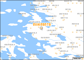
Riihiranta (Länsi-Suomen Lääni, Finland)Riihiranta is a town in the Länsi-Suomen Lääni region of Finland. An overview map of the region around Riihiranta is displayed below.
regional and 3d topo map of Riihiranta, Finland ::
Riihiranta airports ::
The nearest airport is TKU - Turku, located 49.8 km south east of Riihiranta.
Other airports nearby include POR - Pori (88.1 km north), MHQ - Mariehamn (105.5 km south west), Nearby towns ::
Hakula (1.5km north west) //
Lopmeri (2.4km north west) //
Pitkäluoto (3.1km north west) //
Kivisilmä (3.8km south) //
Lokalahti (2.3km south east) //
Ruissaari (4.3km south) //
Tirkkala (2.9km south west) //
Varanpää (2.6km west) //
Väättäinen (3.9km north east) //
Mattinen (3.1km east) //
Salmenperä (3.3km east) //
Hermansaari (4.1km south east) //
Kytämäki (5.8km north east) //
Maahaaro (6.9km north) //
Arvassalo (8.4km north) //
Korpi (4.3km east) //
Sundholm (8.4km north) //
Kouvoinen (8.8km south) //
Vartsaari (7.6km south east) //
Maaharo (7.7km north west) //
[all distances 'as the bird flies' and approximate] 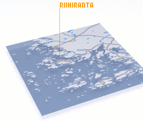 Places with similar names to Riihiranta, Finland ::
// Riihiranta (FI)
Disclaimer :: Information on this page comes without warranty of any kind |
||
|
Where is Riihiranta? Elevation and coordinates ::
Latitude (lat): 60°41'31"N Longitude (lon): 21°25'41"E
(map arrows pan, magnifying glasses zoom) |
||
|
Visiting Riihiranta? Hotel/Accommodation ::
Book a hotel in Riihiranta Travel Guide ::
Buy a travel guide for Finland rental cars ::
car rental offers GPS waypoint ::
download a GPX waypoint (PoI) of Riihiranta for your GPS receiver
|
||