|
search place name
|
||
Stolpas (Länsi-Suomen Lääni, Finland)Stolpas is a town in the Länsi-Suomen Lääni region of Finland. An overview map of the region around Stolpas is displayed below.
regional and 3d topo map of Stolpas, Finland ::

Stolpas airports ::
The nearest airport is VAA - Vaasa, located 15.4 km north east of Stolpas.
Other airports nearby include KAU - Kauhava (76.6 km east), UME - Umea (116.2 km north west), KOK - Kruunupyy (117.0 km north east), POR - Pori (164.3 km south), Nearby towns ::
Vias (0.8km east) //
Smulterbacken (0.8km east) //
Mattlars (0.8km west) //
Havras (2.0km south east) //
Övermalax (2.0km south east) //
Maalahti (1.7km west) //
Malax (1.7km west) //
Kalasar (2.5km north east) //
Alnäset (3.8km south) //
Forsen (3.8km south) //
Klockarbacken (2.5km north west) //
Kråkbacken (4.1km south east) //
Tuvesbacken (4.1km south east) //
Brohugget (2.5km east) //
Färdis Brännan (2.5km east) //
Kopparby (2.5km west) //
Storbacken (3.1km south east) //
Brinken (3.1km north west) //
Berts (3.1km north west) //
Köpings (3.1km north west) //
Alskog (3.1km north west) //
Långmossen (5.6km south) //
Munsmo (5.8km north) //
Bertlasmossa (4.5km south west) //
Kärrmetholmen (5.8km south) //
Langerskogen (3.4km east) //
Junkars (3.8km south east) //
Västersolf (7.5km north) //
Brännan (3.8km north west) //
[all distances 'as the bird flies' and approximate] 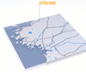
Disclaimer :: Information on this page comes without warranty of any kind |
||
|
Where is Stolpas? Elevation and coordinates ::
Latitude (lat): 62°56'0"N Longitude (lon): 21°36'0"E
(map arrows pan, magnifying glasses zoom) |
||
|
Visiting Stolpas? Hotel/Accommodation ::
Book a hotel in Stolpas Travel Guide ::
Buy a travel guide for Finland rental cars ::
car rental offers GPS waypoint ::
download a GPX waypoint (PoI) of Stolpas for your GPS receiver
|
||