|
search place name
|
||
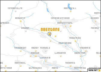
Aberdare (United Kingdom)Aberdare is a town in United Kingdom. An overview map of the region around Aberdare is displayed below.
regional and 3d topo map of Aberdare, United Kingdom ::
Aberdare airports ::
The nearest airport is CWL - Cardiff, located 36.1 km south of Aberdare.
Other airports nearby include SWS - Swansea (45.6 km west), BRS - Bristol (61.9 km south east), FZO - Bristol Filton (62.3 km east), GLO - Golouchestershire Gloucestershire (89.5 km east), Nearby towns ::
Aber-nant (1.1km east) //
Aberaman (1.9km south) //
Abercanaid (3.0km north east) //
Ferndale (5.7km south) //
Merthyr Tydfil (5.1km north east) //
Cefn-coed-y-cymmer (6.0km north) //
Mountain Ash (5.1km south east) //
Maerdy (6.5km south west) //
Dowlais (5.9km north east) //
Llanwonno (7.8km south) //
Rhondda (8.2km south west) //
Treorky (8.7km south west) //
[all distances 'as the bird flies' and approximate]  Places with similar names to Aberdare, United Kingdom ::
Disclaimer :: Information on this page comes without warranty of any kind |
||
|
Where is Aberdare? Elevation and coordinates ::
Latitude (lat): 51°43'0"N Longitude (lon): 3°26'0"W
Elevation (approx.): 152m (map arrows pan, magnifying glasses zoom) |
||
|
Visiting Aberdare? Hotel/Accommodation ::
Book a hotel in Aberdare Travel Guide ::
rental cars ::
car rental offers GPS waypoint ::
download a GPX waypoint (PoI) of Aberdare for your GPS receiver
|
||