|
search place name
|
||
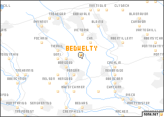
Bedwelty (United Kingdom)Bedwelty is a town in United Kingdom. An overview map of the region around Bedwelty is displayed below.
regional and 3d topo map of Bedwelty, United Kingdom ::
Bedwelty airports ::
The nearest airport is CWL - Cardiff, located 35.2 km south of Bedwelty.
Other airports nearby include FZO - Bristol Filton (46.7 km south east), BRS - Bristol (48.6 km south east), SWS - Swansea (61.0 km west), GLO - Golouchestershire Gloucestershire (74.5 km east), Nearby towns ::
Aber-bargoed (2.3km west) //
Cwm (3.9km north) //
New Tredegar (3.0km north west) //
Aberbeeg (3.0km north east) //
Bargoed (3.0km south west) //
Pengam (3.9km south) //
Victoria (5.6km north) //
Deri (3.4km west) //
Tir-Phil (3.9km north west) //
Gelligaer (5.1km south west) //
Hengoed (6.0km south) //
Crumlin (5.0km east) //
Maes y Cwmmer (7.5km south) //
Blaina (7.8km north) //
Newbridge (5.9km south east) //
Mynyddislwyn (7.8km south) //
Nelson (7.2km south west) //
Abercarn (7.2km south east) //
Ystradmynach (8.2km south west) //
Cwmcarn (8.7km south east) //
[all distances 'as the bird flies' and approximate] 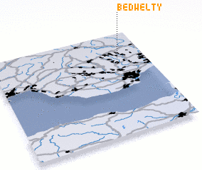 Places with similar names to Bedwelty, United Kingdom :: Disclaimer :: Information on this page comes without warranty of any kind |
||
|
Where is Bedwelty? Elevation and coordinates ::
Latitude (lat): 51°42'0"N Longitude (lon): 3°12'0"W
Elevation (approx.): 294m (map arrows pan, magnifying glasses zoom) |
||
|
Visiting Bedwelty? Hotel/Accommodation ::
Book a hotel in Bedwelty Travel Guide ::
rental cars ::
car rental offers GPS waypoint ::
download a GPX waypoint (PoI) of Bedwelty for your GPS receiver
|
||